 Filter: Categories of Wisconsin Historical Images
Filter: Subject of Wisconsin River (Wis.)
Filter: Year of 1800-1899
Filter: Categories of Wisconsin Historical Images
Filter: Subject of Wisconsin River (Wis.)
Filter: Year of 1800-1899

| Date: | 1835 |
|---|---|
| Description: | Plat for a proposed Sinsinawa City (never built), in Grant County, Wis. When it became clear in the mid-1830s that Wisconsin Territory would be established... |

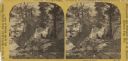
| Date: | 06 24 1878 |
|---|---|
| Description: | Stereograph of three men at the top of Stand Rock. One man is standing holding his rifle, while the two other people are sitting. Text at right: "Wandering... |
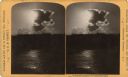
| Date: | 1890 |
|---|---|
| Description: | Sunlight shining through a cloud, illuminating the water below. "Text at right: "Wanderings Among the Wonders and Beauties of Wisconsin Scenery." |
| Date: | 1869 |
|---|---|
| Description: | Two girls in long dresses on a rock formation. The river and far shoreline is in the background. Text on left reads: "A Visit to Devil's Lake, Sauk County,... |

| Date: | 1877 |
|---|---|
| Description: | This 1877 map of Sauk County, Wisconsin, shows the township and range grid, sections, towns, cities and villages, land ownership and acreages, wagon roads,... |

| Date: | 1875 |
|---|---|
| Description: | These maps, from G.K. Warren's 1876 Report on the transportation route along the Wisconsin and Fox rivers in the State of Wisconsin between the Mississippi... |

| Date: | 1868 |
|---|---|
| Description: | Map showing the northern water routes between Mississippi River and Atlantic Ocean Relief shown by hachures. Includes Profile of the Erie Canal, table of ... |

| Date: | 1875 |
|---|---|
| Description: | This map, from G.K. Warren's 1876 Report on the transportation route along the Wisconsin and Fox Rivers in the State of Wisconsin between the Mississippi R... |

| Date: | 1875 |
|---|---|
| Description: | One of a set of maps from G.K. Warren's 1876 Report on the transportation route along the Wisconsin and Fox rivers in the State of Wisconsin between the Mi... |

| Date: | 11 30 1882 |
|---|---|
| Description: | This 1882 manuscript map shows the improvements to a 12-mile stretch of the Wisconsin River below Portage, in Columbia County, Wisconsin. Recent improvemen... |

| Date: | 1866 |
|---|---|
| Description: | This manuscript map by Increase Lapham shows the Dells of the Wisconsin River, from Stand Rock and Witches Gulch at the north to a point approximately one ... |

| Date: | 1850 |
|---|---|
| Description: | This 1850 survey by William H. Canfield shows the mounds near Wiegands Bay on the Wisconsin River in the Town of Merrimac, Sauk County, Wisconsin. |

| Date: | 1859 |
|---|---|
| Description: | Shows townships and sections, landownership, roads, railroads, rural residences, schools, churches, and topography. Relief shown by hachures. "From governm... |

| Date: | 1890 |
|---|---|
| Description: | Shows vacant state land, government land, townships, and selected farms, camps, saw mills, etc. in Vilas and Oneida Counties, and part of Iron County. "For... |

| Date: | 1887 |
|---|---|
| Description: | Map of the Fox and Wisconsin Rivers to accompany Reuben Gold Thwaites' Historic Waterways. |

| Date: | 1887 |
|---|---|
| Description: | This map of Tomahawk shows the Wisconsin River, numbered lots, and labeled streets. The back of the map reads: "Henry C. Payne, 424 Broadway, - - Milwaukee... |
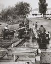
| Date: | 1887 |
|---|---|
| Description: | A raft of lumber which has been floated down the Wisconsin River to be broken up and sold. Two men are standing on the raft, each near lumber stacked on a ... |

| Date: | 1890 |
|---|---|
| Description: | Group of tourists and crew members on the bow deck of the DELL QUEEN, an excursion boat that operated on the Wisconsin River at Wisconsin Dells. |

| Date: | 1880 |
|---|---|
| Description: | View of flood damage, showing wrecked buildings along the Wisconsin River waterfront. |
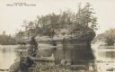
| Date: | 1888 |
|---|---|
| Description: | Photographic postcard view from shoreline of the rock formation in the Dells of the Wisconsin River. A man is paddling a canoe in the foreground. Printed o... |
If you didn't find the material you searched for, our Library Reference Staff can help.
Call our reference desk at 608-264-6535 or email us at: