 Filter: Categories of Wisconsin Historical Images
Filter: Subject of Wisconsin River (Wis.)
Filter: Year of 1800-1899
Filter: Subject of transportation
Filter: Categories of Wisconsin Historical Images
Filter: Subject of Wisconsin River (Wis.)
Filter: Year of 1800-1899
Filter: Subject of transportation

| Date: | 1875 |
|---|---|
| Description: | One of a set of maps from G.K. Warren's 1876 Report on the transportation route along the Wisconsin and Fox rivers in the State of Wisconsin between the Mi... |

| Date: | 1892 |
|---|---|
| Description: | A Sanborn fire insurance map of Sauk City which was drawn up in 1892. |
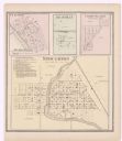
| Date: | 1873 |
|---|---|
| Description: | A page showing four plat maps: Stoughton, Clifton, Deanville, and Cross Plains. |

| Date: | 1891 |
|---|---|
| Description: | The index page of a Sanborn Map of Stevens Point. |
If you didn't find the material you searched for, our Library Reference Staff can help.
Call our reference desk at 608-264-6535 or email us at: