 Filter: Categories of Wisconsin Historical Images
Filter: Subject of Wisconsin River (Wis.)
Filter: County of Columbia
Filter: Year of 1900-1999
Filter: Categories of Wisconsin Historical Images
Filter: Subject of Wisconsin River (Wis.)
Filter: County of Columbia
Filter: Year of 1900-1999

| Date: | 1936 |
|---|---|
| Description: | This map is red and black ink on tracing cloth and is oriented with north to the upper left. This hand-drawn map shows a central portion of the military ro... |
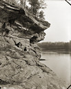
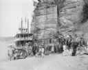
| Date: | 1900 |
|---|---|
| Description: | View along rockface shoreline towards a woman and two children sitting on Angel Rock. Along a cliff along the opposite shoreline are buildings and a bridge... |
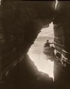
| Date: | 1906 |
|---|---|
| Description: | View out of Skylight Cave towards a man in a boat at the entrance to the cave. |

| Date: | 1950 |
|---|---|
| Description: | A man operating a ticket booth in the Wisconsin Dells. He is playing a card game, probably solitaire, on the counter. |
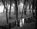
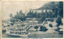
| Date: | 09 22 1962 |
|---|---|
| Description: | Elevated view of trees and pool of water near the Wisconsin River in Pauquette Park. |

| Date: | 1928 |
|---|---|
| Description: | "The Dells," a brochure issued by the Chicago, Milwaukee & St. Paul and Pacific Railroad to advertise the Wisconsin Dells, a destination only five hours fr... |

| Date: | 1906 |
|---|---|
| Description: | Promotional brochure for the Wisconsin Dells (then known as Kilbourn) issued by the Chicago, Milwaukee & St. Paul Railway. The railroad illustrated many of... |
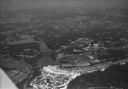
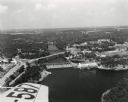
| Date: | 1930 |
|---|---|
| Description: | Aerial view of the town of Wisconsin Dells, the dam on the Wisconsin River, and the generating plant. The town of Wisconsin Dells was known as Kilbourn Cit... |
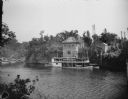
| Date: | 1910 |
|---|---|
| Description: | Elevated view across water toward the Larks Hotel and ferry. Caption reads: "Larks Hotel, Wisconsin Dells." |
| Date: | 1959 |
|---|---|
| Description: | The Kilbourn Hydroelectric Plant of the Wisconsin Power and Light Company. |

| Date: | 1930 |
|---|---|
| Description: | Aerial view of Wisconsin Dells including the Wisconsin River and the dam and generating power plant. |
| Date: | 1955 |
|---|---|
| Description: | Aerial view of Wisconsin Dells. The wing of the airplane is in the left foreground. |
| Date: | 1940 |
|---|---|
| Description: | Aerial view of the Wisconsin Power and Light Company generating plant and dam. |
| Date: | 1922 |
|---|---|
| Description: | View from shoreline across river towards the steamboat "Winnebago" docked at the Dells Boat Landing on the opposite shoreline. |
| Date: | 1929 |
|---|---|
| Description: | Ceremonial performers in traditional Indian costume pose near a steamboat. |
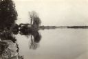
| Date: | 1935 |
|---|---|
| Description: | The Wisconsin River looking downstream. The Wisconsin River end of the canal may be seen at the left. |
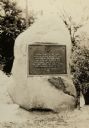
| Date: | 1928 |
|---|---|
| Description: | The Pierre Pauquette monument, located on the bank of the Wisconsin River where he operated a ferry between the years 1828 and 1836. Erected by the Wau-bun... |
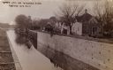
| Date: | 1910 |
|---|---|
| Description: | The Portage Canal at the Wisconsin River, showing the upper lock. Caption reads: "Upper Lock and Wisconsin River Portage Wis. No. 10". A group of people ar... |

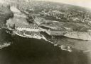
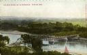
| Date: | 1945 |
|---|---|
| Description: | An aerial view of the Portage Canal, Fox and Wisconsin Rivers. |
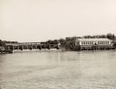
| Date: | 1900 |
|---|---|
| Description: | Elevated view of a bridge over the Wisconsin River. Caption reads: "The New Bridge on the Wisconsin, Portage, Wis." |
If you didn't find the material you searched for, our Library Reference Staff can help.
Call our reference desk at 608-264-6535 or email us at: