 Filter: Categories of Wisconsin Historical Images
Filter: Subject of Wisconsin River (Wis.)
Filter: Creator Name of Unknown
Filter: Subject of trees
Filter: Categories of Wisconsin Historical Images
Filter: Subject of Wisconsin River (Wis.)
Filter: Creator Name of Unknown
Filter: Subject of trees
| Date: | |
|---|---|
| Description: | View along right side of shoreline toward a Chicago, Minneapolis, and St. Paul train crossing a bridge over the Wisconsin River. |

| Date: | 1879 |
|---|---|
| Description: | This map is a bird's-eye view of Wausau, the County Seat of Marathon County. The map features an index of points of interest. |

| Date: | 1928 |
|---|---|
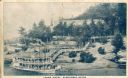
| Description: | "The Dells," a brochure issued by the Chicago, Milwaukee & St. Paul and Pacific Railroad to advertise the Wisconsin Dells, a destination only five hours fr... |

| Date: | 1906 |
|---|---|
| Description: | Promotional brochure for the Wisconsin Dells (then known as Kilbourn) issued by the Chicago, Milwaukee & St. Paul Railway. The railroad illustrated many of... |
| Date: | |
|---|---|
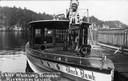
| Description: | Chief Whirling Thunder, standing at the front of an excursion boat named "Black Hawk," which appears to be near the Wisconsin Dells. Caption reads: "Chief ... |
| Date: | 1911 |
|---|---|
| Description: | Winter scene, probably along the Wisconsin River, possibly near Taliesin, the home of Frank Lloyd Wright. Taliesin is located in the vicinity of Spring Gre... |

| Date: | 1920 |
|---|---|
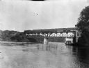
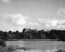
| Description: | Bridge over river from shoreline seen through trees in the spring or summer. Part of the bridge is covered. |
| Date: | 1920 |
|---|---|
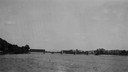
| Description: | View across water towards the partially covered bridge. A wooded shoreline is along the left and right. |

| Date: | 1920 |
|---|---|
| Description: | Aerial view of the last covered bridge, which is no longer standing. |
| Date: | 1910 |
|---|---|
| Description: | Elevated view across water toward the Larks Hotel and ferry. Caption reads: "Larks Hotel, Wisconsin Dells." |
| Date: | 1945 |
|---|---|
| Description: | View of the Wausau Memorial Hospital, with the Wisconsin River in the foreground. |
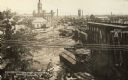
| Date: | 07 1912 |
|---|---|
| Description: | Elevated view across the Wisconsin River, showing the wreckage left by the disastrous flood of July 24, 1912. A power dam on the Wisconsin River above Waus... |

| Date: | 1905 |
|---|---|
| Description: | View across water toward East Hill. Caption reads: "East Hill, from Depot Grounds, Wausau, Wis." |

| Date: | 1900 |
|---|---|
| Description: | View from bank of river towards the Cereal Mills Company, looking North toward Big Bull Falls. |
| Date: | 1950 |
|---|---|
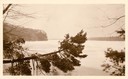
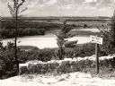
| Description: | A view from a bluff on Tower HIll overlooking the Wisconsin River. A sign on the right reads: "Shot Shaft". |
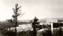
| Date: | 1945 |
|---|---|
| Description: | View from the bluff at Tower Hill State Park of the Wisconsin River. A sign on the right reads: "Tower Hill State Park Shot Shaft". |

| Date: | 1910 |
|---|---|
| Description: | View across grass towards a wagon bridge on the left crossing the Wisconsin River at Stevens Point. Caption reads: "Wagon Bridge, across Wisconsin River, S... |

| Date: | 1965 |
|---|---|
| Description: | Aerial view that encompasses most of the town and part of the Wisconsin River. |
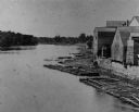
| Date: | 1880 |
|---|---|
| Description: | Elevated view of the Wisconsin River shoreline, showing lumber rafts "tied up over Sunday." |
If you didn't find the material you searched for, our Library Reference Staff can help.
Call our reference desk at 608-264-6535 or email us at:
