 Filter: Categories of Wisconsin Historical Images
Filter: Subject of Wisconsin
Filter: Subject of oneida indians
Filter: Categories of Wisconsin Historical Images
Filter: Subject of Wisconsin
Filter: Subject of oneida indians
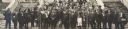
| Date: | 10 1914 |
|---|---|
| Description: | Fourth Annual Conference of American Indians taken in front of Lathrop Hall, University of Wisconsin-Madison campus. Included are: Mr. (William) Kershaw (M... |

| Date: | 1858 |
|---|---|
| Description: | A survey map that shows the status of township surveys in Wisconsin. At that point, the majority of the state had been surveyed and platted, with the area... |

| Date: | 1864 |
|---|---|
| Description: | This map of the entire state of Wisconsin depicts the township survey grid and identifies counties, named towns, cities and villages, rivers, lakes, railro... |

| Date: | 1865 |
|---|---|
| Description: | This map of the entire state of Wisconsin depicts the township survey grid and identifies counties, named towns, cities and villages, rivers, lakes, railro... |

| Date: | 1867 |
|---|---|
| Description: | A hand-colored map of Wisconsin showing the state’s township grid, lakes, rivers, railroads, as well as the locations of towns, counties and the reservatio... |

| Date: | 1871 |
|---|---|
| Description: | This map of Wisconsin and surrounding states depicts the township survey grid and identifies counties, named towns, cities and villages, rivers, lakes, rai... |

| Date: | 1871 |
|---|---|
| Description: | This map of Wisconsin and surrounding states depicts the township survey grid and identifies counties, named towns, cities and villages, rivers, lakes, rai... |

| Date: | 1875 |
|---|---|
| Description: | This hand-colored map of Wisconsin and the western portion of Michigan's Upper Peninsula depicts the township survey grid and identifies counties, named to... |

| Date: | 1878 |
|---|---|
| Description: | A hand-colored, cloth mounted, sectional map of Wisconsin and the western portion of Michigan’s Upper Peninsula, showing the township grid, railroads, town... |

| Date: | 1880 |
|---|---|
| Description: | A hand-colored, sectional map of Wisconsin showing the township grid, railroads, counties, towns, cities, villages, and the Menomonee, Oneida, Flambeau, an... |

| Date: | 1882 |
|---|---|
| Description: | A hand-colored, sectional map of Wisconsin showing the township grid, completed and proposed railroads, counties, towns, cities, villages. The map also inc... |

| Date: | 1930 |
|---|---|
| Description: | A map of the site of a Native American village with a complex of linear raised garden beds and cache pits near Leeman. Also shown are a farmstead, road, an... |
If you didn't find the material you searched for, our Library Reference Staff can help.
Call our reference desk at 608-264-6535 or email us at: