Filter: Categories of Wisconsin Historical Images
Filter: Subject of Wisconsin
Filter: Subject of military art and science
Filter: Categories of Wisconsin Historical Images
Filter: Subject of Wisconsin
Filter: Subject of military art and science

| Date: | 1842 |
|---|---|
| Description: | This hand-colored lithograph of the second Fort Howard, with Indians canoeing on the Fox River, shows the hospital built 1834-1835 outside the stockade on ... |
| Date: | 1940 |
|---|---|
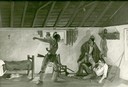
| Description: | Photograph of a painting by Cal Peters depicting the Winnebago attack on the Gagnier homestead in 1827 and the killing of Registre Gagnier. The homestead w... |
| Date: | 1845 |
|---|---|
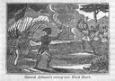
| Description: | Engraving depicting the defeat of Black Hawk by General Henry Atkinson at the Battle of Bad Axe on August 2, 1832. The engraving depicts Federal Regulars a... |

| Date: | 1997 |
|---|---|
| Description: | A watercolor of four arrowheads used by PaleoIndians from Wisconsin. The types from left to right are: clovis, folsum, lanceolate and scottsbluff. |
| Date: | |
|---|---|
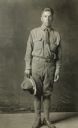
| Description: | Gus Sharlow, a Native American Indian World War I soldier from Hayward, Wisconsin. |
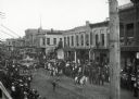
| Date: | |
|---|---|
| Description: | Crowds of individuals assembled on the sides of the street to watch parading soldiers, and Native Americans riding horses. Looking east on Main Street from... |
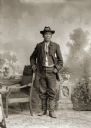
| Date: | 1900 |
|---|---|
| Description: | Full-length studio portrait of a Ho-Chunk man posing standing next to a chair, identified as Homer Snake, who is wearing a hat with a GAR emblem, signifyin... |

| Date: | 1846 |
|---|---|
| Description: | A hand-colored map of Wisconsin shows the counties in the state south and east of the Wisconsin and Fox rivers and the locations of Indian lands to the nor... |
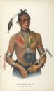
| Date: | 1849 |
|---|---|
| Description: | Hand-colored lithograph of Little Elk (Hoo-Wan-ne-ka), chief of the Ho-Chunk, as he appeared during an official visit to Washington, D.C. in 1824. This por... |

| Date: | |
|---|---|
| Description: | A map of southern Wisconsin and northern Illinois showing where the battles took place and routes taken by Black Hawk and his band during the Black Hawk Wa... |

| Date: | 1800 |
|---|---|
| Description: | This map is pencil on tracing paper and shows marshes, the Wisconsin River, Indian trails, and Indian boundary line. The upper left corner reads: "Let sect... |

| Date: | |
|---|---|
| Description: | This map is pen-and-ink on tracing paper with a mounted legend and shows the Kickapoo River, Indian mounds, the 1st Fort Crawford, an Indian Agency, the si... |
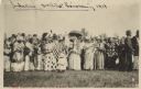
| Date: | 06 19 1919 |
|---|---|
| Description: | A gathering of Native American women, some holding flags, to welcome home soldiers returning from WWI on Corpus Christi Day. There are men in the backgroun... |

| Date: | 1929 |
|---|---|
| Description: | This map with north oriented to the upper left shows military forts, Indian villages, settler's houses with surnames, trading houses, lodges and encampment... |

| Date: | 1900 |
|---|---|
| Description: | This manuscript map shows outline of Fort Winnebago reserve land, Fort Winnebago, claim of A. Grignon, and Indian boundaries. The Fox River and Swan Lake a... |

| Date: | 1758 |
|---|---|
| Description: | This detailed map of north eastern America shows the boundaries, cities, mountains, rivers, lakes, Native American land and towns, and roads from east of t... |

| Date: | 1720 |
|---|---|
| Description: | Map showing the course of the Mississippi River from the Gulf of Mexico up past Lake Superior into Canada. It shows the towns, Native American tribes and l... |

| Date: | 1755 |
|---|---|
| Description: | Map of the Great Lakes region during the French and Indian War. It shows in great detail the territories, borders and boundary lines, Native American tribe... |
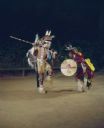
| Date: | |
|---|---|
| Description: | Two Native American Indian men, dressed in ceremonial clothing and holding spears and shields, are performing the Warrior's Dance at the Stand Rock Indian ... |
If you didn't find the material you searched for, our Library Reference Staff can help.
Call our reference desk at 608-264-6535 or email us at: