 Filter: Categories of Wisconsin Historical Images
Filter: Subject of Wisconsin
Filter: Subject of menominee indians
Filter: Year of 1800-1899
Filter: Categories of Wisconsin Historical Images
Filter: Subject of Wisconsin
Filter: Subject of menominee indians
Filter: Year of 1800-1899
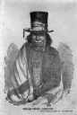
| Date: | 1850 |
|---|---|
| Description: | Drawing of Chief Oshkosh rendered from a daguerreotype by J.F. Harrison. He is wearing a top hat wrapped with a ribbon. Also a suitcoat, bowtie, beaded nec... |

| Date: | 1858 |
|---|---|
| Description: | A survey map that shows the status of township surveys in Wisconsin. At that point, the majority of the state had been surveyed and platted, with the area... |

| Date: | 1875 |
|---|---|
| Description: | This hand-colored map of Wisconsin and the western portion of Michigan's Upper Peninsula depicts the township survey grid and identifies counties, named to... |

| Date: | 1878 |
|---|---|
| Description: | A hand-colored, cloth mounted, sectional map of Wisconsin and the western portion of Michigan’s Upper Peninsula, showing the township grid, railroads, town... |

| Date: | 1880 |
|---|---|
| Description: | A hand-colored, sectional map of Wisconsin showing the township grid, railroads, counties, towns, cities, villages, and the Menomonee, Oneida, Flambeau, an... |

| Date: | 1882 |
|---|---|
| Description: | A hand-colored, sectional map of Wisconsin showing the township grid, completed and proposed railroads, counties, towns, cities, villages. The map also inc... |
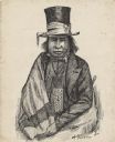
| Date: | 1850 |
|---|---|
| Description: | Waist-up pen and ink drawing of Chief Oshkosh. He is wearing a top hat wrapped with a ribbon. He wears a suitcoat, bowtie, beaded neckpouch and a blanket w... |
If you didn't find the material you searched for, our Library Reference Staff can help.
Call our reference desk at 608-264-6535 or email us at: