 Filter: Categories of Wisconsin Historical Images
Filter: Subject of Wisconsin
Filter: Subject of menominee indians
Filter: Categories of Wisconsin Historical Images
Filter: Subject of Wisconsin
Filter: Subject of menominee indians
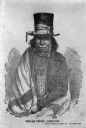
| Date: | 1850 |
|---|---|
| Description: | Drawing of Chief Oshkosh rendered from a daguerreotype by J.F. Harrison. He is wearing a top hat wrapped with a ribbon. Also a suitcoat, bowtie, beaded nec... |
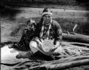
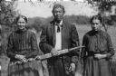
| Date: | |
|---|---|
| Description: | Indian basket maker with her child. |
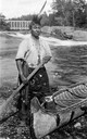
| Date: | 1925 |
|---|---|
| Description: | A portrait of a descendant of Chief Oshkosh, probably Ernest Oshkosh, with one foot in a traditional canoe. This image is part of an exhibit about Native A... |
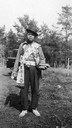
| Date: | 1922 |
|---|---|
| Description: | Charlie Duchmann, a Menominee, photographed in 1922. This image is part of an exhibit about Native Americans prepared by Paul Vanderbilt, the Wisconsin Hi... |

| Date: | 1909 |
|---|---|
| Description: | A Menominee child, probably photographed on the reservation near Keshena and Neopit, Wisconsin. He is standing outside in front of a log cabin, and an axe ... |
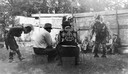
| Date: | 1942 |
|---|---|
| Description: | A Menominee ceremonial dance. The dancers are wearing Native American ceremonial dress. Although Roman Catholic missions had banned many Native American ce... |
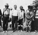
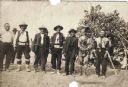
| Date: | 1910 |
|---|---|
| Description: | A group of prominent Menominee: (from left to right) Wisanokwut, Wiuskasit, Thomas Hog, Kesoafomesao, Louise Amore (or Amour), and Judge Perrote. This pho... |
| Date: | 1931 |
|---|---|
| Description: | A portrait of a Menominee family in traditional dress. This image is part of an exhibit about Native Americans prepared by Paul Vanderbilt. |

| Date: | 1910 |
|---|---|
| Description: | Sawmill on a Menominee Indian reservation, with logs floating in the water in the foreground. Caption reads: "Menominee Indian Mills." |

| Date: | |
|---|---|
| Description: | A Menominee Indian Village on Wolf River. There are dwellings on the shore and many people in canoes are on the river. |
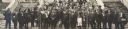
| Date: | 10 1914 |
|---|---|
| Description: | Fourth Annual Conference of American Indians taken in front of Lathrop Hall, University of Wisconsin-Madison campus. Included are: Mr. (William) Kershaw (M... |
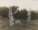
| Date: | 10 07 1914 |
|---|---|
| Description: | Sara (Mrs. Joseph) Mallon (Menominee) of Milwaukee, wearing a sash stands between two American flags behind a memorial that reads, "Indian Mounds: One of s... |
| Date: | |
|---|---|
| Description: | Outdoor portrait of a Menominee Indian man and two Menominee Indian women. The man is holding a decorated ceremonial pipe in his right hand. |
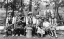
| Date: | 1910 |
|---|---|
| Description: | A group of prominent Menominee: (from left to right) Alex Warrington, unidentified fishman, John Rain, Louise Waukechon, Pinto, Black Jack Warrington (John... |

| Date: | 1858 |
|---|---|
| Description: | A survey map that shows the status of township surveys in Wisconsin. At that point, the majority of the state had been surveyed and platted, with the area... |

| Date: | 1979 |
|---|---|
| Description: | A map of Southern Wisconsin and northern Illinois showing the areas inhabited by the Ho-Chuck, formerly known as the Winnebago. Some of the location names ... |

| Date: | 1875 |
|---|---|
| Description: | This hand-colored map of Wisconsin and the western portion of Michigan's Upper Peninsula depicts the township survey grid and identifies counties, named to... |

| Date: | 1878 |
|---|---|
| Description: | A hand-colored, cloth mounted, sectional map of Wisconsin and the western portion of Michigan’s Upper Peninsula, showing the township grid, railroads, town... |

| Date: | 1880 |
|---|---|
| Description: | A hand-colored, sectional map of Wisconsin showing the township grid, railroads, counties, towns, cities, villages, and the Menomonee, Oneida, Flambeau, an... |

| Date: | 1882 |
|---|---|
| Description: | A hand-colored, sectional map of Wisconsin showing the township grid, completed and proposed railroads, counties, towns, cities, villages. The map also inc... |
If you didn't find the material you searched for, our Library Reference Staff can help.
Call our reference desk at 608-264-6535 or email us at: