 Filter: Categories of Wisconsin Historical Images
Filter: Subject of Wisconsin
Filter: Subject of land
Filter: Categories of Wisconsin Historical Images
Filter: Subject of Wisconsin
Filter: Subject of land

| Date: | 1688 |
|---|---|
| Description: | This map includes vignettes of Amerindian life with text describing geography, culture, and exploration activity, written in French. The Great Lakes, river... |

| Date: | 1952 |
|---|---|
| Description: | The famous Dells of the Wisconsin River. A souvenir map embellished with bits of history and points of interest. |
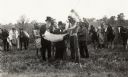
| Date: | 1949 |
|---|---|
| Description: | Historical re-enactment outdoors, in inappropriate attire, probably meant to represent a treaty signing, at the Grignon House. |

| Date: | 1930 |
|---|---|
| Description: | This map shows Indian trails through Wisconsin counties. The trail are in red ink. Lake Michigan, Green Bay, Lake Superior, and the Wisconsin River are lab... |

| Date: | |
|---|---|
| Description: | Letterhead of the Kewaskum Mutual Fire Insurance Company of Washington County, Wisconsin, with a Native American man wearing buckskin clothes and leggings ... |
| Date: | 1905 |
|---|---|
| Description: | A reproduction of the Wisconsin portion of Samuel de Champlain's 1632 map showing the location of the La Nation du Puans, or Ho-Chunk Indians, located next... |

| Date: | 1905 |
|---|---|
| Description: | A reproduction of the Wisconsin portion of Louis Hennepin's 1698 map showing the location of the Ho-Chunk Tribe, the Hurons, the Illinois as well as other ... |

| Date: | 1846 |
|---|---|
| Description: | A hand-colored map of Wisconsin shows the counties in the state south and east of the Wisconsin and Fox rivers and the locations of Indian lands to the nor... |

| Date: | 1899 |
|---|---|
| Description: | This color map, originally published in the Smithsonian Institution Bureau of American Ethnology's 18th annual report, shows the Indian land cessions in Wi... |

| Date: | 1943 |
|---|---|
| Description: | A map that shows the lands for sale by the Tomahawk Land Company of Tomahawk, Wisconsin, in the counties of Langlade, Lincoln, Oneida, and Price. The map s... |

| Date: | 1851 |
|---|---|
| Description: | Map of a portion of Merton including the Bark River, a mill, Fort Hill, and Indian mounds. |

| Date: | 1937 |
|---|---|
| Description: | Label submitted to the state of Wisconsin for trademark registration. "Pioneer Beer, G. Weber Brewing Co." Under this in the center is a leaf with the lett... |

| Date: | 1939 |
|---|---|
| Description: | Label submitted to the state of Wisconsin for trademark registration. "Superfine Marathon Beer, Marathon City Brewing Company." In the foreground of the im... |

| Date: | 1880 |
|---|---|
| Description: | A hand-colored map of the Chippewa, Price, Taylor and the northern part of Clark counties, which shows the locations of farmhouses, schoolhouses, churches,... |

| Date: | 1916 |
|---|---|
| Description: | In 1916, it was estimated that 15,000 Indian mounds had formerly existed in Wisconsin. In the early 20th century, the Wisconsin Archaeological Society surv... |

| Date: | 1979 |
|---|---|
| Description: | A map of Southern Wisconsin and northern Illinois showing the areas inhabited by the Ho-Chuck, formerly known as the Winnebago. Some of the location names ... |

| Date: | |
|---|---|
| Description: | A map of southern Wisconsin and northern Illinois showing where the battles took place and routes taken by Black Hawk and his band during the Black Hawk Wa... |

| Date: | 1864 |
|---|---|
| Description: | This map of the entire state of Wisconsin depicts the township survey grid and identifies counties, named towns, cities and villages, rivers, lakes, railro... |

| Date: | 1865 |
|---|---|
| Description: | This map of the entire state of Wisconsin depicts the township survey grid and identifies counties, named towns, cities and villages, rivers, lakes, railro... |

| Date: | 1871 |
|---|---|
| Description: | This map of Wisconsin and surrounding states depicts the township survey grid and identifies counties, named towns, cities and villages, rivers, lakes, rai... |
If you didn't find the material you searched for, our Library Reference Staff can help.
Call our reference desk at 608-264-6535 or email us at: