 Filter: Categories of Wisconsin Historical Images
Filter: Subject of Wisconsin
Filter: Subject of human settlements
Filter: Subject of transportation
Filter: Categories of Wisconsin Historical Images
Filter: Subject of Wisconsin
Filter: Subject of human settlements
Filter: Subject of transportation

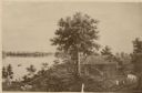
| Date: | 1893 |
|---|---|
| Description: | Back of painting reads: "Madison in June 1837 after photo taken by E.E. Bailey" and "Peck's cabin by Dengel." The Eben Peck cabin was the first house built... |

| Date: | 1852 |
|---|---|
| Description: | Illustration of four Indians on Madeline Island with a canoe in the water on the shore. |

| Date: | |
|---|---|
| Description: | A Menominee Indian Village on Wolf River. There are dwellings on the shore and many people in canoes are on the river. |

| Date: | 1955 |
|---|---|
| Description: | Artist's conception of ancient village of Aztalan, fortified with high walls surrounding it. |

| Date: | 1915 |
|---|---|
| Description: | A row of conical burial mounds adjoins the Park and Pleasure Drive on the north shore of Lake Wingra (now Edgewood Drive, at the south edge of Edgewood Col... |
| Date: | 1877 |
|---|---|
| Description: | Photograph of a painting of the exterior of the Eben Peck cabin by Mrs. E.E. Bailey. The location of this original painting is unknown. |

| Date: | |
|---|---|
| Description: | View of two small Native American children standing on the city scale. Across the street is a horse-drawn wagon near commercial buildings. |
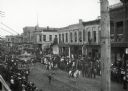
| Date: | |
|---|---|
| Description: | Crowds of individuals assembled on the sides of the street to watch parading soldiers, and Native Americans riding horses. Looking east on Main Street from... |

| Date: | |
|---|---|
| Description: | Map reads: "Historic and Scenic Wisconsin — Land of Gathering Waters." In an inset there is a hand-painted depiction of the Wisconsin State Seal. For some ... |

| Date: | 1920 |
|---|---|
| Description: | View of a supposed Indian "trail tree," on former Mercer's addition or subdivision, now the corner of Elm and Van Hise Streets near Madison West High Schoo... |
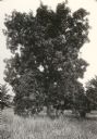
| Date: | 1920 |
|---|---|
| Description: | View of a supposed Indian "trail tree," on former Mercer's addition or subdivision, now the corner of Chestnut and Van Hise Streets, near Madison West High... |

| Date: | 1920 |
|---|---|
| Description: | View of a supposed Indian "trail tree" on former Mercer's addition or subdivision, now the corner of Chestnut and Van Hise Streets, near Madison West High ... |

| Date: | |
|---|---|
| Description: | View of a supposed Indian "trail tree" on former Mercer's addition or subdivision, now the corner of Elm and Van Hise Streets, near Madison West High Schoo... |

| Date: | |
|---|---|
| Description: | View down wooden sidewalk towards a Ho-Chunk man smoking a cigar and wearing a duck bone breast plate and fur pants on the left, and a European American ma... |

| Date: | 1930 |
|---|---|
| Description: | This map shows Indian trails through Wisconsin counties. The trail are in red ink. Lake Michigan, Green Bay, Lake Superior, and the Wisconsin River are lab... |

| Date: | |
|---|---|
| Description: | Letterhead of the Kewaskum Mutual Fire Insurance Company of Washington County, Wisconsin, with a Native American man wearing buckskin clothes and leggings ... |

| Date: | 1880 |
|---|---|
| Description: | A hand-colored map of the Chippewa, Price, Taylor and the northern part of Clark counties, which shows the locations of farmhouses, schoolhouses, churches,... |

| Date: | 1864 |
|---|---|
| Description: | This map of the entire state of Wisconsin depicts the township survey grid and identifies counties, named towns, cities and villages, rivers, lakes, railro... |

| Date: | 1865 |
|---|---|
| Description: | This map of the entire state of Wisconsin depicts the township survey grid and identifies counties, named towns, cities and villages, rivers, lakes, railro... |

| Date: | 1867 |
|---|---|
| Description: | A hand-colored map of Wisconsin showing the state’s township grid, lakes, rivers, railroads, as well as the locations of towns, counties and the reservatio... |
If you didn't find the material you searched for, our Library Reference Staff can help.
Call our reference desk at 608-264-6535 or email us at: