 Filter: Categories of Wisconsin Historical Images
Filter: Subject of Wisconsin
Filter: Subject of human settlements
Filter: Creator Name of Unknown
Filter: Categories of Wisconsin Historical Images
Filter: Subject of Wisconsin
Filter: Subject of human settlements
Filter: Creator Name of Unknown

| Date: | 1852 |
|---|---|
| Description: | Illustration of four Indians on Madeline Island with a canoe in the water on the shore. |
| Date: | |
|---|---|
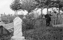
| Description: | Man posing by a gate in the Red Cliff Indian Reservation cemetery. |

| Date: | |
|---|---|
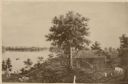
| Description: | A Menominee Indian Village on Wolf River. There are dwellings on the shore and many people in canoes are on the river. |
| Date: | |
|---|---|
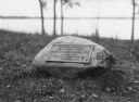
| Description: | View of a rock with a plaque that reads: "Group of Prehistoric Indian Burial Mounds and Winnebago Village Site. Marked by the Delavan Woman's Club - May 19... |
| Date: | 1877 |
|---|---|
| Description: | Photograph of a painting of the exterior of the Eben Peck cabin by Mrs. E.E. Bailey. The location of this original painting is unknown. |
| Date: | |
|---|---|
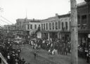
| Description: | Crowds of individuals assembled on the sides of the street to watch parading soldiers, and Native Americans riding horses. Looking east on Main Street from... |
| Date: | 1920 |
|---|---|
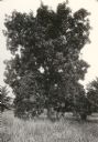
| Description: | View of a supposed Indian "trail tree," on former Mercer's addition or subdivision, now the corner of Chestnut and Van Hise Streets, near Madison West High... |

| Date: | 1920 |
|---|---|
| Description: | View of a supposed Indian "trail tree" on former Mercer's addition or subdivision, now the corner of Chestnut and Van Hise Streets, near Madison West High ... |

| Date: | |
|---|---|
| Description: | View of a supposed Indian "trail tree" on former Mercer's addition or subdivision, now the corner of Elm and Van Hise Streets, near Madison West High Schoo... |

| Date: | |
|---|---|
| Description: | Wisconsin Memorial Hospital with a key to buildings in the upper left. Indian mounds are marked on the site. Arthur Peabody was the state architect for th... |
| Date: | |
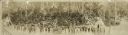
|---|---|
| Description: | Panoramic view of a large group of Native Americans posed in front of Stand Rock between two tipis. |
| Date: | |
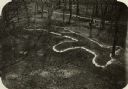
|---|---|
| Description: | Elevated view of bear effigy mound outlined in chalk at Lake Koshkonong. |

| Date: | 1927 |
|---|---|
| Description: | Blueprint-style map of Frost Woods on the shore of Lake Monona. The map indicates the locations of Indian mounds, an Indian camp, and various plants. There... |
| Date: | 07 05 1928 |
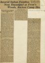
|---|---|
| Description: | Article entitled "Several Indian Families Now Encamped at Frost's Woods, Ancient Camp Site" about Winnebago (Ho-Chunk) Indians camping on the shores of Lak... |
| Date: | 07 28 1926 |
|---|---|
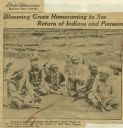
| Description: | Newspaper clipping including headline, photograph of six Winnebago (Ho Chunk) Indians, and a caption indicating that the men pictured would be attending a ... |

| Date: | |
|---|---|
| Description: | Letterhead of the Kewaskum Mutual Fire Insurance Company of Washington County, Wisconsin, with a Native American man wearing buckskin clothes and leggings ... |

| Date: | |
|---|---|
| Description: | A map of southern Wisconsin and northern Illinois showing where the battles took place and routes taken by Black Hawk and his band during the Black Hawk Wa... |

| Date: | 1935 |
|---|---|
| Description: | Two hand-colored maps of the area comprising the town of Millston (Plats of Townships 20 and 21 north, range 2 west), Jackson County, Wisconsin, showing 40... |

| Date: | 1838 |
|---|---|
| Description: | This map is a development plat that shows street names, numbered blocks and lots, and small farm lot owners. Included on the right of the map is a large am... |

| Date: | |
|---|---|
| Description: | This map is pen-and-ink on tracing paper with a mounted legend and shows the Kickapoo River, Indian mounds, the 1st Fort Crawford, an Indian Agency, the si... |
If you didn't find the material you searched for, our Library Reference Staff can help.
Call our reference desk at 608-264-6535 or email us at: