 Filter: Categories of Wisconsin Historical Images
Filter: Subject of Winnebago Indians
Filter: Subject of water
Filter: Categories of Wisconsin Historical Images
Filter: Subject of Winnebago Indians
Filter: Subject of water
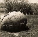
| Date: | 1920 |
|---|---|
| Description: | The inscription on the rock reads: "Ah-Dah-Wa-Gam Chapter D.A.R. In recognition of the Loyalty & Patriotism of the Winnebago Indians." "General Foster Deco... |

| Date: | 1941 |
|---|---|
| Description: | Hand-drawn, watercolor and ink, map of Lake Mendota. Locations and many small figures appear around the shore with explanations referring to Indian legends... |

| Date: | 1905 |
|---|---|
| Description: | A reproduction of the Wisconsin portion of Louis Hennepin's 1698 map showing the location of the Ho-Chunk Tribe, the Hurons, the Illinois as well as other ... |

| Date: | 1857 |
|---|---|
| Description: | A map of the state of Wisconsin and the southeastern portion of the Territory of Minnesota, showing the Wisconsin reservations of the Oneida, Menominee, St... |

| Date: | 1860 |
|---|---|
| Description: | A survey map of Wisconsin, southeastern Minnesota, and northern Iowa, showing the status of surveys, rivers, and lakes. The map also shows the locations of... |

| Date: | 1979 |
|---|---|
| Description: | A map of Southern Wisconsin and northern Illinois showing the areas inhabited by the Ho-Chuck, formerly known as the Winnebago. Some of the location names ... |
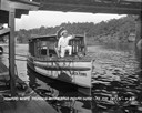
| Date: | 1929 |
|---|---|
| Description: | View from pier of a Native American man wearing a headdress kneeling on a tourist boat called "Black Hawk" docked under a bridge in the Wisconsin River. He... |
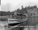
| Date: | 1929 |
|---|---|
| Description: | Native American guide in native dress standing on the bow of a tour boat floating in the river. A pilot wearing a hat is sitting behind him. On the front o... |
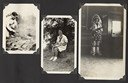
| Date: | |
|---|---|
| Description: | Page from Joy Camps photo album displaying three photographs. In one photograph Barbara Ellen Joy, camp owner and co-director, cooks over a large grill are... |

| Date: | 1945 |
|---|---|
| Description: | This maps shows roads, railroads, parks, recreational areas, Lake Wingra, Lake Monona, and part of Lake Mendota. The map includes pictorial images that dep... |

| Date: | 1930 |
|---|---|
| Description: | This map shows rivers, lakes, trails, Indian villages, distances, and boundaries of tracts ceded by the Munnomonee, Winnebaygoes, and New York Indians Trib... |

| Date: | 1947 |
|---|---|
| Description: | This map shows the territories of Chippewa, Sioux, Winnebago, and Monomone tribes. It also shows navigation notes for rivers and lakes, Indian villages, hi... |
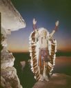
| Date: | |
|---|---|
| Description: | Sam (Carley) Blowsnake performing at the Stand Rock Indian Ceremonial, the Sunrise Call of the Zuni. He is dressed in Native American ceremonial clothing w... |
If you didn't find the material you searched for, our Library Reference Staff can help.
Call our reference desk at 608-264-6535 or email us at: