 Filter: Categories of Wisconsin Historical Images
Filter: Subject of Winnebago Indians
Filter: Subject of human settlements
Filter: Categories of Wisconsin Historical Images
Filter: Subject of Winnebago Indians
Filter: Subject of human settlements
| Date: | 1920 |
|---|---|
| Description: | In recognition of the loyalty and patronage of the Winnebago Indians. |

| Date: | 1857 |
|---|---|
| Description: | A map of the state of Wisconsin and the southeastern portion of the Territory of Minnesota, showing the Wisconsin reservations of the Oneida, Menominee, St... |
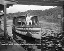
| Date: | 1929 |
|---|---|
| Description: | View from pier of a Native American man wearing a headdress kneeling on a tourist boat called "Black Hawk" docked under a bridge in the Wisconsin River. He... |
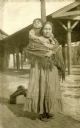
| Date: | 1922 |
|---|---|
| Description: | Portrait of Josh Sanford as a child with his mother, Maude Decorah. Sanford served in the Army Air Corps during WWII and is credited with being the only Na... |

| Date: | 1930 |
|---|---|
| Description: | This map shows rivers, lakes, trails, Indian villages, distances, and boundaries of tracts ceded by the Munnomonee, Winnebaygoes, and New York Indians Trib... |

| Date: | 1936 |
|---|---|
| Description: | Text on front reads: "Winnebago Chiefs." One of 16 postcard images inside of a souvenir view folder. Two Native American Chiefs wearing indigenous clothing... |
If you didn't find the material you searched for, our Library Reference Staff can help.
Call our reference desk at 608-264-6535 or email us at: