Filter: Categories of Wisconsin Historical Images
Filter: Subject of Waterfalls
Filter: Year of 1800-1899
Filter: Subject of rivers
Filter: Categories of Wisconsin Historical Images
Filter: Subject of Waterfalls
Filter: Year of 1800-1899
Filter: Subject of rivers

| Date: | 1864 |
|---|---|
| Description: | This map shows pictorially a section of bracketdam, section of tree dam, and crib of stone. This map was prepared by order of General Joseph Bailey and is ... |
| Date: | 1877 |
|---|---|
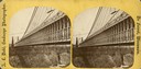
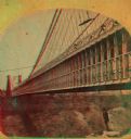
| Description: | An A.L. Dahl photograph, one of "Two different side views of the Suspension Bridge," from the series "Niagara Falls and Suspension Bridge" as mentioned in ... |
| Date: | 1880 |
|---|---|
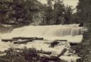
| Description: | Willow River Falls. Text at right reads: "Published by Whitney's Gallery, St. Paul, Minn. Willow River Falls Near Hudeson, Wis." |
| Date: | 1885 |
|---|---|
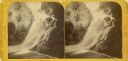
| Description: | Stereograph of Kinnikinnick Falls, north branch. |
| Date: | 1885 |
|---|---|
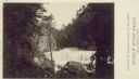
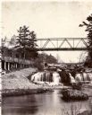
| Description: | View looking up river towards the Kinnickinnic Falls. A bridge is above the falls. |
| Date: | 1890 |
|---|---|
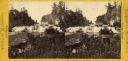
| Description: | Stereograph of Big Manitou Falls on the Black River. This waterfall reportedly was called "Gitchee Monido" by the Ojibwa, which means "Falls of the Great S... |

| Date: | 1890 |
|---|---|
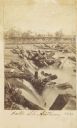
| Description: | Big Manitou Falls on the Black River. This waterfall reportedly was called "Gitchee Monido" by the Ojibwa, which means "Falls of the Great Spirit." |
| Date: | 1877 |
|---|---|
| Description: | An A.L. Dahl photograph, one of "Two different side views of the Suspension Bridge," from the series "Niagara Falls and Suspension Bridge" as mentioned in ... |

| Date: | 01 09 1849 |
|---|---|
| Description: | Shows county line boundaries, rivers, and falls. Includes explanation of township and county divisions. Pen and pencil on paper. Title supplied by cataloge... |
| Date: | 1863 |
|---|---|
| Description: | Carte-de-visite view of the Falls of Saint Anthony and logs caught on rocks in the falls. |
| Date: | 1856 |
|---|---|
| Description: | Lithographic view of the Grande Chute Falls on the Fox River. There is a tent on the shore on the right. |

| Date: | 1846 |
|---|---|
| Description: | This map shows the plotting of the various townships in Wisconsin, both those that had been surveyed and some outlines for those which have not. A note in ... |
If you didn't find the material you searched for, our Library Reference Staff can help.
Call our reference desk at 608-264-6535 or email us at: