Filter: Categories of Wisconsin Historical Images
Filter: Subject of Water-supply
Filter: Subject of cities and towns
Filter: Year of 1900-1999
Filter: Categories of Wisconsin Historical Images
Filter: Subject of Water-supply
Filter: Subject of cities and towns
Filter: Year of 1900-1999
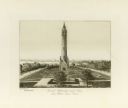
| Date: | 1906 |
|---|---|
| Description: | Water tower near East Washington Avenue, that stood from 1890 to 1920. Horse-drawn vehicles are parked at the base of the tower. |
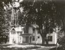
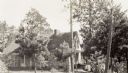
| Date: | 1922 |
|---|---|
| Description: | The J.C. Hawley house, also known as the Evergreens, which stood on a site at Badger Road that later became a highway interchange. A water tower is on the ... |
| Date: | 1910 |
|---|---|
| Description: | Elevated view from hill toward the building which has two large smokestacks. The Lake Michigan shoreline is on the left. In front is a landscaped area with... |
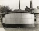
| Date: | 1930 |
|---|---|
| Description: | Storage Tank #2. A large, rounded tank with a conical roof. Another tank is directly behind. A large brick building is on the right. |

| Date: | 1930 |
|---|---|
| Description: | West side of filter building. Pipes are stacked on the right side of the building, and part of a storage tank can be seen on the left. |

| Date: | 1930 |
|---|---|
| Description: | Front view of pump room, side of part of Boiler Room. |
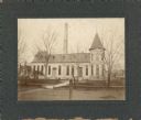
| Date: | 1945 |
|---|---|
| Description: | Exterior view of the stone-walled headquarters building of the Water Regulatory Board located within a grove of trees. According to text included with the ... |
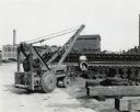
| Date: | 1946 |
|---|---|
| Description: | International I-4 industrial tractor with crane owned by the Milwaukee Waterworks. Original caption reads: "The city of Milwaukee, Wisconsin, purchased thi... |
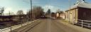
| Date: | 11 16 1989 |
|---|---|
| Description: | View from the Water Street Bridge over the Waupaca River toward the Waupaca Water Department. |
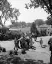
| Date: | 08 30 1953 |
|---|---|
| Description: | A crowd lining up at a drinking fountain (bubbler) in Vilas Park. |
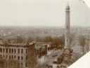
| Date: | 1910 |
|---|---|
| Description: | The Madison waterworks building, with corner tower and turret. The building was located at the corner of Gorham and Livingston Streets. The large smokesta... |

| Date: | 1947 |
|---|---|
| Description: | Lower left hand corner features a legend. "Drawn 1938, revised 1947." Shows water mains, hydrants, corporation limits, city ward divisions, fire proof buil... |

| Date: | 1908 |
|---|---|
| Description: | Shows pipes of various sizes, hydrants, valves, and wells. "1907" -- Lower margin. Lake Wingra, Lake Monona, and Lake Mendota are labelled. |
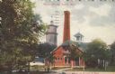
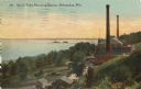
| Date: | 1919 |
|---|---|
| Description: | Colorized postcard view of the water works, smokestack and water tower. People are lounging under the trees in front. Caption reads: "Water Works, Beloit, ... |

| Date: | 04 1901 |
|---|---|
| Description: | A Sanborn map of Watertown, including an index and a key. |

| Date: | 11 07 1949 |
|---|---|
| Description: | Subject: "Pipe Lines — TD-6." Where Taken: "NE." Information with photograph reads: "TD-6 owned by J.J. Struzziery-General Contractors, 115 Kittredge St., ... |
If you didn't find the material you searched for, our Library Reference Staff can help.
Call our reference desk at 608-264-6535 or email us at: