Filter: Categories of Wisconsin Historical Images
Filter: Subject of Water towers
Filter: Subject of aerial photographs
Filter: Categories of Wisconsin Historical Images
Filter: Subject of Water towers
Filter: Subject of aerial photographs

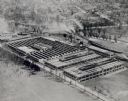
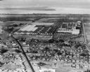
| Date: | 1942 |
|---|---|
| Description: | Aerial view of Oscar Mayer & Company, 910 Mayer Avenue at Packers Avenue. Shows stock yards, railroad cars and automobile parking lot. Also shows C.E. & P.... |

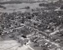
| Date: | 1965 |
|---|---|
| Description: | Aerial view that encompasses most of the town and part of the Wisconsin River. |
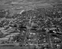
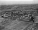
| Date: | 1957 |
|---|---|
| Description: | Aerial view of town with multiple buildings and a water tower visible in the background. |

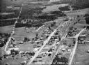
| Date: | 1957 |
|---|---|
| Description: | Aerial view of town including water tower, city streets, houses, and other buildings. |
| Date: | 1957 |
|---|---|
| Description: | Aerial view of town including houses, water tower, city streets and buildings. |
| Date: | 1954 |
|---|---|
| Description: | An aerial view of the International Harvester Memphis Works in Memphis, Tennessee, with a view of the surrounding neighborhood and Loosahatchie River. The ... |
| Date: | 1930 |
|---|---|
| Description: | Aerial view of International Harvester's St. Paul Flax Twine Mill. |

| Date: | 10 10 1947 |
|---|---|
| Description: | Aerial view of Dundas cannery. |
| Date: | 1910 |
|---|---|
| Description: | Aerial view of the factory surrounded by fields, roads, and several houses, as well as the railroad tracks that go around the building. Caption reads: "Wes... |
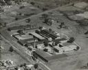
| Date: | 1966 |
|---|---|
| Description: | St. Mary's Hospital and surrounding area. In the bottom left corner is the water tower. |

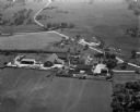
| Date: | |
|---|---|
| Description: | Aerial view includes farm and orchards, surrounded by neighborhoods. A water tower is on the upper left half. |
| Date: | 04 27 1949 |
|---|---|
| Description: | Aerial view of the Veterans Hospital at Tomah. |
| Date: | 1942 |
|---|---|
| Description: | Aerial view of the Quad City Tank Arsenal. |

| Date: | |
|---|---|
| Description: | Aerial view of a developed strip of land on Barnegat Bay showing the Atlantic ocean, houses, lakes, railroad tracks, a marina and a jetty in the distance. |

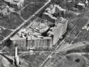
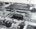
| Date: | 1960 |
|---|---|
| Description: | Aerial view of the Dane County Hospital, looking west. Excavating for a more modern east wing that was finished in 1960 can be seen near the main building.... |

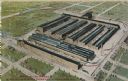
| Date: | 1930 |
|---|---|
| Description: | Aerial view of International Harvester's Milwaukee Works. |
| Date: | 1936 |
|---|---|
| Description: | Aerial view of Cable, in northern Wisconsin. Text at foot reads: "Airplane View of Cable, Wis. 244." |

| Date: | 09 1996 |
|---|---|
| Description: | "Theresa's Bonduel & Wisconsin Streets from the air." |
If you didn't find the material you searched for, our Library Reference Staff can help.
Call our reference desk at 608-264-6535 or email us at: