 Filter: Categories of Wisconsin Historical Images
Filter: Subject of Water
Filter: Year of 1800-1899
Filter: Year of 1850-1859
Filter: Categories of Wisconsin Historical Images
Filter: Subject of Water
Filter: Year of 1800-1899
Filter: Year of 1850-1859
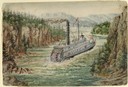
| Date: | 1858 |
|---|---|
| Description: | In August 1858, Hölzlhuber traveled up the St. Croix River to Stillwater, Minnesota, on the steamship Winona. He noted the upper Mississippi's tribu... |

| Date: | 1851 |
|---|---|
| Description: | A rare photograph of U.S. Army soldiers stationed at Fort Howard rowing a boat on the Fox River. Fort Howard, built in 1816, was the first in the chain of ... |
| Date: | 1856 |
|---|---|
| Description: | Painting by S.M. Brookes of the Wisconsin Heights Battlefield. |

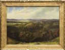
| Date: | 1856 |
|---|---|
| Description: | This landscape painting by Samuel Marsden Brookes and Thomas H. Stevenson depicts a broad view of the confluence of Bad Axe and Mississippi Rivers; site of... |

| Date: | 10 1852 |
|---|---|
| Description: | Landscape view of the river looking downstream from Fort Snelling, Minnesota Territory. An expanse of placid river water fills the center of the drawing an... |

| Date: | 1855 |
|---|---|
| Description: | Bird's-eye view of Madison. "Taken from the Water Cure, South Side of Lake Monona, 1855." |

| Date: | 1852 |
|---|---|
| Description: | Illustration of four Indians on Madeline Island with a canoe in the water on the shore. |

| Date: | 1852 |
|---|---|
| Description: | An illustration of a storm encountered by a delegation of Indians on their way to Washington, D.C. |

| Date: | 1856 |
|---|---|
| Description: | This map show the surveyed southern part of state and includes "profile of the Milwaukee and Mississippi Rail Road." Counties are shown in pink, green, blu... |

| Date: | 1855 |
|---|---|
| Description: | Quarter plate daguerreotype of the Oshkosh harbor, showing the bridge over the Fox River and several moored sailing vessels. |
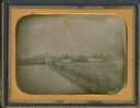
| Date: | 1855 |
|---|---|
| Description: | Half plate daguerreotype, with view across water of the Oshkosh, Wisconsin harbor showing the bridge over the Fox River. Moored on the opposite shore are t... |

| Date: | 1850 |
|---|---|
| Description: | Painting depicting Chippewa Falls and the first sawmill on the Chippewa River, built by Jean Brunet. The residence of H.S. Allen, one of the owners of the... |

| Date: | 1850 |
|---|---|
| Description: | Travelers in a rowing canoe on Lake Superior. |

| Date: | 1850 |
|---|---|
| Description: | Elevated view of the Lake Superior shoreline, with terraces leading to the beach. A canoe is on the shoreline. |

| Date: | 1850 |
|---|---|
| Description: | Pastoral scene depicting a small bay on the Island of St. Ignace in Lake Superior with canoes on the rocky beach, two men conversing on a blanket in the fo... |

| Date: | 1850 |
|---|---|
| Description: | Pic Island on the north shore of Lake Superior. |

| Date: | 1851 |
|---|---|
| Description: | Plat map of the Town of Madison (Township 7N, Range 9E), from Volume 4, Federal Survey Plat Books. |

| Date: | 1852 |
|---|---|
| Description: | Illustration of the Ojibwa, the Sacs, and Foxes battling from canoes on the water. |

| Date: | 1856 |
|---|---|
| Description: | View looking west from Lake Michigan with several steam ships and sailing vessels in harbor. There is a lighthouse to left of center, along shoreline. |
If you didn't find the material you searched for, our Library Reference Staff can help.
Call our reference desk at 608-264-6535 or email us at:
