 Filter: Categories of Wisconsin Historical Images
Filter: Subject of Water
Filter: Year of 1800-1899
Filter: Categories of Wisconsin Historical Images
Filter: Subject of Water
Filter: Year of 1800-1899

| Date: | 1803 |
|---|---|
| Description: | Cours du Mississippi : comprenant la Louisiane, les 2 Florides, une partie des Etats-Unis, et pays adjacents. |

| Date: | 1889 |
|---|---|
| Description: | Stereograph of a posed scene showing a woman milking a cow as two other women stand waiting at an open barn door. On the left a man at a hand-pump is behin... |
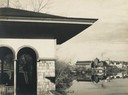
| Date: | 04 24 1899 |
|---|---|
| Description: | Partial view of a boathouse at the foot of North Carroll Street, designed by Frank Lloyd Wright and built for the city of Madison. The University of Wiscon... |

| Date: | 1821 |
|---|---|
| Description: | Engraving of the Pictured Rocks shoreline viewed from Lake Superior. |

| Date: | 1821 |
|---|---|
| Description: | Engraving depicting the Schoolcraft expedition crossing the Ontonagon River to investigate a copper boulder. |

| Date: | 1850 |
|---|---|
| Description: | Travelers in a rowing canoe on Lake Superior. |

| Date: | 1850 |
|---|---|
| Description: | Elevated view of the Lake Superior shoreline, with terraces leading to the beach. A canoe is on the shoreline. |

| Date: | 1850 |
|---|---|
| Description: | Pastoral scene depicting a small bay on the Island of St. Ignace in Lake Superior with canoes on the rocky beach, two men conversing on a blanket in the fo... |

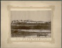
| Date: | 1850 |
|---|---|
| Description: | Pic Island on the north shore of Lake Superior. |

| Date: | 1851 |
|---|---|
| Description: | Plat map of the Town of Madison (Township 7N, Range 9E), from Volume 4, Federal Survey Plat Books. |

| Date: | 1873 |
|---|---|
| Description: | Map of the township of Windsor, from the "Atlas of Dane County." |

| Date: | 1848 |
|---|---|
| Description: | In 1849, northern Wisconsin was composed of huge sectional regions such as Chippewa, Portage, Brown and Crawford, whereas southern Wisconsin was constitute... |

| Date: | 1873 |
|---|---|
| Description: | Newspaper reproduction of an etching of the Milwaukee River. |

| Date: | 1852 |
|---|---|
| Description: | Illustration of the Ojibwa, the Sacs, and Foxes battling from canoes on the water. |

| Date: | 1800 |
|---|---|
| Description: | Needlework scene on silk worked in colored silk thread using running and crewel stitches. The hands and faces of the figures are watercolor on paper. Sce... |
| Date: | 1840 |
|---|---|
| Description: | Photograph of a painting of the second Fort Crawford, built 1829-1835. Two men are in a boat in the water in the foreground. The first Fort Crawford at Pra... |
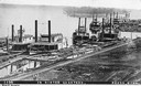
| Date: | 1872 |
|---|---|
| Description: | Elevated view of nine rafters wintering at Reed's Landing. At left is Hiram Price, with L.W. Crane beside her. Third is Annie Girdon w... |
If you didn't find the material you searched for, our Library Reference Staff can help.
Call our reference desk at 608-264-6535 or email us at:


