 Filter: Categories of Wisconsin Historical Images
Filter: Subject of Water
Filter: Year of 1800-1899
Filter: County of Winnebago
Filter: Categories of Wisconsin Historical Images
Filter: Subject of Water
Filter: Year of 1800-1899
Filter: County of Winnebago

| Date: | 1870 |
|---|---|
| Description: | This bird's-eye-view map shows roads, a river with boats, and homes. The bottom margin of the map includes an index. |

| Date: | 1855 |
|---|---|
| Description: | Quarter plate daguerreotype of the Oshkosh harbor, showing the bridge over the Fox River and several moored sailing vessels. |

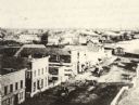
| Date: | 1850 |
|---|---|
| Description: | Bird's-eye view of business district of Oshkosh, "drawn after nature" by the artist. |

| Date: | 1867 |
|---|---|
| Description: | Bird's-eye view of Oshkosh, "drawn from nature." |

| Date: | 1833 |
|---|---|
| Description: | Map of part of the military road from Fort Crawford to Fort Howard. "Recorded on pages 668.669 Book B." Surveyed by Lieut. Center. Scale: 2 miles = 1 inch. |
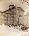
| Date: | 1893 |
|---|---|
| Description: | Institutional fire fighting department at the Northern Hospital for the Insane, executing drills on the exterior of the building. Fire fighting equipment i... |

| Date: | 1870 |
|---|---|
| Description: | Elevated view of City Square, where the Bank of Menasha is seen on the corner and Little Lake Butte des Mortes is in the distance. |
| Date: | 1870 |
|---|---|
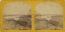
| Description: | Elevated view of Main Street looking east toward the Fox River and the boat landing. Lake Winnebago is in the distance. |

| Date: | 1870 |
|---|---|
| Description: | The corner of unpaved Main Street and Tayco Street looking south towards Doty Island. The slanting timbers controlled the primitive draw bridge across the ... |
| Date: | 1870 |
|---|---|
| Description: | A stereograph of the Menasha Wooden Ware factory. |

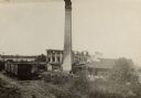
| Date: | 08 24 1888 |
|---|---|
| Description: | The George A. Whiting Paper Mill after a fire on August 24, 1888. Sixteen men were killed by the explosion of a bleacher; the bleacher exploded as the nigh... |
| Date: | 08 24 1888 |
|---|---|
| Description: | Slightly elevated view of the George A. Whiting Paper Mill after a fire on August 24, 1888. Sixteen men were killed by the explosion of a bleacher; the ble... |
| Date: | 1870 |
|---|---|
| Description: | Stereograph of an elevated view of the industrial section along the Fox River in Menasha. During this period the millers in Menasha were beginning to inves... |

| Date: | 1840 |
|---|---|
| Description: | This map surveyed under the direction of Captain Thomas J. Cram is one in a series of seventeen that accompanied Cram's report on the Fox-Wisconsin river s... |
| Date: | 1870 |
|---|---|
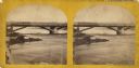
| Description: | Stereograph view of Cedar Street Bridge(?) with a rocky shoreline on the left. The construction of this bridge is the same as the Cedar Street bridge, but ... |
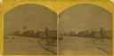
| Date: | 1870 |
|---|---|
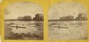
| Description: | Stereograph view across what may be the Fox River, or a field with snow on the ground. There are large buildings behind a fence in the background. Caption ... |
| Date: | 1870 |
|---|---|
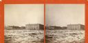
| Description: | Stereograph view of the flour mill district. The Cedar Street Bridge is in the background, and the mills are, right to left going back, the Winnebago Flour... |

| Date: | 1870 |
|---|---|
| Description: | Stereograph of flour mill district. The Walnut Street bridge is in the background and the mill to the right is the Atlantic Mills (Neenah Stone Mills in 18... |
If you didn't find the material you searched for, our Library Reference Staff can help.
Call our reference desk at 608-264-6535 or email us at:

