Filter: Categories of Wisconsin Historical Images
Filter: Subject of Water
Filter: Subject of trees
Filter: County of Dane
Filter: Categories of Wisconsin Historical Images
Filter: Subject of Water
Filter: Subject of trees
Filter: County of Dane
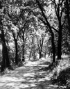
| Date: | 1930 |
|---|---|
| Description: | View of the Lakeshore Path in Bascom Woods by Lake Mendota, later dedicated the Howard M. Temin Lake Shore Path on the University of Wisconsin-Madison camp... |
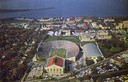
| Date: | 1963 |
|---|---|
| Description: | Aerial view of Camp Randall during a football game on the University of Wisconsin-Madison campus with Picnic Point in the background. |

| Date: | 1956 |
|---|---|
| Description: | Aerial view of lower University of Wisconsin-Madison campus with demolition of buildings on both sides of the Armory-Gymnasium to make space for future pla... |
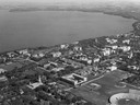
| Date: | 1947 |
|---|---|
| Description: | Aerial of University of Wisconsin-Madison campus with Camp Randall in the lower right corner and Lake Mendota, looking northeast to Maple Bluff. |

| Date: | 1956 |
|---|---|
| Description: | Aerial view of upper campus of the University of Wisconsin-Madison with Lake Mendota. |
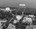
| Date: | 1958 |
|---|---|
| Description: | Aerial view of upper campus on the University of Wisconsin-Madison. Typewritten labels mark the location of Elizabeth Waters Hall, New Commerce Building, L... |

| Date: | 1946 |
|---|---|
| Description: | Aerial view of University of Wisconsin-Madison campus with Bascom Hill area, Observatory Drive and Lake Mendota. |

| Date: | 1929 |
|---|---|
| Description: | View of the College of Agriculture on the University of Wisconsin Madison campus as seen from the tower of the First Congressional Church. |
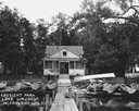
| Date: | 08 1927 |
|---|---|
| Description: | A young boy sits on the dock in front of Olson's store in Crescent Park on Lake Waubesa. Small row boats are arrayed for rental. |
| Date: | 1888 |
|---|---|
| Description: | View of shoreline along Picnic Point on the University of Wisconsin-Madison campus showing the home of Professor William Daniels, head of the Chemistry Dep... |
| Date: | 1900 |
|---|---|
| Description: | Elevated view of Observatory Hill on the University of Wisconsin Madison campus of the United States National, Wisconsin State Farm Experiment Station, Pro... |
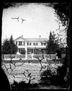
| Date: | |
|---|---|
| Description: | View from the road of a frame house behind a picket fence, with cut work, shutters, and lightning rods by each chimney and a well in front of the fence. V... |
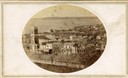
| Date: | 1861 |
|---|---|
| Description: | First block of East Main street photographed from the roof of the Wisconsin State Capitol building. Doty and Wilson street properties and Lake Monona are i... |
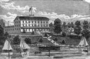
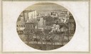
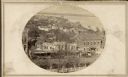
| Date: | 1861 |
|---|---|
| Description: | The Vilas Hotel located at the corner of Monona Avenue at the west end of the first block of East Main Street. |
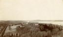
| Date: | 1865 |
|---|---|
| Description: | South Wisconsin Avenue and West Main Street. Lake Monona is in the background and the Lucius Fairchild and David Atwood houses are at the upper left. The r... |

| Date: | |
|---|---|
| Description: | View of East Mifflin Street taken from the Wisconsin State Capitol roof. The building in the foreground, at the corner of East Mifflin and North Pinckney S... |

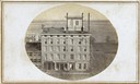
| Date: | |
|---|---|
| Description: | View of East Mifflin and North Pinckney Streets from the roof of the Wisconsin State Capitol building. This is the first block of East Mifflin Street. Nort... |
| Date: | |
|---|---|
| Description: | View of North Pinckney Street from the Capitol roof. The Methodist Episcopal church is located in the left of this image. |
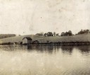
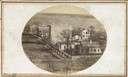
| Date: | 1859 |
|---|---|
| Description: | South Pinckney Street as photographed by Fuller from the Wisconsin State Capitol roof. In the center are several wooden structures dating from Madison's e... |
If you didn't find the material you searched for, our Library Reference Staff can help.
Call our reference desk at 608-264-6535 or email us at: