 Filter: Categories of Wisconsin Historical Images
Filter: Subject of Water
Filter: Subject of trees
Filter: Type of Map or Atlas
Filter: Year of 1900-1999
Filter: Categories of Wisconsin Historical Images
Filter: Subject of Water
Filter: Subject of trees
Filter: Type of Map or Atlas
Filter: Year of 1900-1999

| Date: | 1930 |
|---|---|
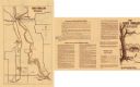
| Description: | Pictorial map of Glacier National Park, Montana and Waterton Lakes National Park, Alberta. Illustrated by Joe Scheurle, it depicts white people, American ... |

| Date: | 1956 |
|---|---|
| Description: | This map shows the types of upland and lowland forest vegetation on Stockton Island, one of the Apostle Islands in Lake Superior. |
| Date: | 1974 |
|---|---|
| Description: | This 1974 map shows historical sites related to Caddie Woodlawn, a book by Carol Ryrie Brink, in the Town of Dunn, Dunn County, Wisconsin. Some landmarks a... |

| Date: | 04 1905 |
|---|---|
| Description: | Map of the Madison, Wisconsin region showing the four major lakes, starting in the north with Lake Mendota, Lake Monona, Lake Waubesa, and Lake Kegonsa. La... |

| Date: | 1976 |
|---|---|
| Description: | This hand-colored map shows land divided by forest type and tree species. Also shown are counties, Lake Michigan, Lake Superior, Lake Winnebago, and the Mi... |

| Date: | 1937 |
|---|---|
| Description: | Pictorial map showing historical events and locations within the state of Wisconsin, as well as waterways and counties. Original caption on the bottom marg... |

| Date: | 08 1960 |
|---|---|
| Description: | This map shows a detailed account of southwestern Wisconsin. Individual settlers, the type of trees that grow in given areas, the quality of the soil (labe... |
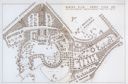
| Date: | 1931 |
|---|---|
| Description: | Fold-out map of the zoo inside a publication titled: "The Master Plan For Henry Vilas Park Zoo." Includes Lake Wingra, the lagoon, and the playground. |

| Date: | 1975 |
|---|---|
| Description: | Colored bird's-eye map of the Lake Region of Waukesha County. Looking North from Government Hill. All these Lakes and Resorts are withing Four hours ride o... |
If you didn't find the material you searched for, our Library Reference Staff can help.
Call our reference desk at 608-264-6535 or email us at: