 Filter: Categories of Wisconsin Historical Images
Filter: Subject of Water
Filter: County of Sauk
Filter: Categories of Wisconsin Historical Images
Filter: Subject of Water
Filter: County of Sauk
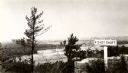
| Date: | 1945 |
|---|---|
| Description: | View from the bluff at Tower Hill State Park of the Wisconsin River. A sign on the right reads: "Tower Hill State Park Shot Shaft". |
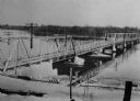
| Date: | 1920 |
|---|---|
| Description: | View of the Wisconsin River Bridge in the vicinity of Spring Green. |

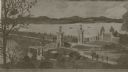
| Date: | 1859 |
|---|---|
| Description: | Map featuring various views of buildings and scenes from Sauk County. |
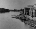
| Date: | 1880 |
|---|---|
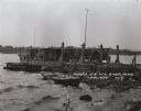
| Description: | Elevated view of the Wisconsin River shoreline, showing lumber rafts "tied up over Sunday." |
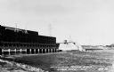
| Date: | 1950 |
|---|---|
| Description: | View of the Wisconsin River dam. |
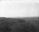
| Date: | 1896 |
|---|---|
| Description: | Elevated view. Caption on negative sleeve reads: "Black Hawk Battlefield. Wis. Heights. 'Looking it of west across river' [sic] c. 1896. Mrs. Charle... |

| Date: | 1925 |
|---|---|
| Description: | View down center of the Wisconsin River bridge. |
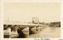
| Date: | 1922 |
|---|---|
| Description: | View of the approach to the Wisconsin River bridge. |
| Date: | 1922 |
|---|---|
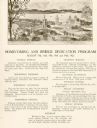
| Description: | Homecoming and bridge dedication program, featuring an image of the approach to the Wisconsin River Bridge, and a listing of the celebration's planned even... |
| Date: | 1925 |
|---|---|
| Description: | View across water along the right side of the Sauk City bridge, erected in 1922 to replace an old toll bridge. tree-covered hills are on the opposite shore... |
| Date: | 1910 |
|---|---|
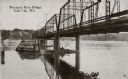
| Description: | View from below along the left side of the Wisconsin River bridge. Tree-covered hills are on the opposite shoreline. Caption reads: "Wisconsin River Bridge... |

| Date: | 1875 |
|---|---|
| Description: | View of the Sauk City bridge as seen from the Roxbury side. Two men are standing on the bridge on the far right, and buildings are behind the bridge on the... |

| Date: | 1909 |
|---|---|
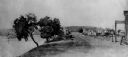
| Description: | Wagon toll bridge. There is a building on the left, and a man is sitting on a bench on the right side of the road leading onto the bridge. |
| Date: | 1930 |
|---|---|
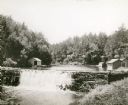
| Description: | View of the mill dam on Dell Creek that creates Mirror Lake in Mirror Lake State Park (although the photograph was taken before the site was designated as ... |
| Date: | 1925 |
|---|---|
| Description: | Car ferry on the Wisconsin River at Merrimac. A ferry has operated at this site since the 1840's. In 1924 the privately owned ferry was replaced by this wo... |
| Date: | 1900 |
|---|---|
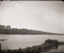
| Description: | Slightly elevated view towards buildings in Prairie du Sac from the east bank of the Wisconsin River. |
| Date: | 1850 |
|---|---|
| Description: | Buildings along Wisconsin River. |
| Date: | |
|---|---|
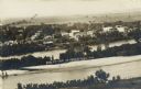
| Description: | Elevated view of buildings lining the river in foreground, with farmland in background. Caption reads: "Bird's Eye View of Prairie Du Sac, Wis." |
If you didn't find the material you searched for, our Library Reference Staff can help.
Call our reference desk at 608-264-6535 or email us at:

