 Filter: Categories of Wisconsin Historical Images
Filter: Subject of Water
Filter: County of Door
Filter: Year of 1800-1899
Filter: Categories of Wisconsin Historical Images
Filter: Subject of Water
Filter: County of Door
Filter: Year of 1800-1899

| Date: | 1890 |
|---|---|
| Description: | A man and three boys in swimming suits at the beach. Presumably, Lake Michigan. |
| Date: | 1888 |
|---|---|
| Description: | Elevated view of men repairing a docked, damaged ship. A shoreline is in the distance. |

| Date: | 1893 |
|---|---|
| Description: | Bird's-eye map of Sturgeon Bay, looking Northeast. Area bordered by Church Street in top left corner, leather & Smith Bridge in bottom left corner, Lawrenc... |

| Date: | 1880 |
|---|---|
| Description: | Bird's-eye map of Sturgeon Bay. County Seat of Door County. |
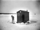
| Date: | 1898 |
|---|---|
| Description: | A boy dressed in knickers clears the ice in preparation to fish next to his family's ice shanty. |

| Date: | 1875 |
|---|---|
| Description: | The harbor piers and the entrance to the Sturgeon Bay ship canal. Men are standing on the shoreline. |

| Date: | 1895 |
|---|---|
| Description: | A view of a dock showing a steam vessel and men with a team of horses towing a log raft. |
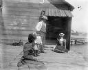
| Date: | 07 1899 |
|---|---|
| Description: | Syl with two women and a man, all wearing hats, fishing off of a dock in Sturgeon Bay. Behind them is a small wooden structure. |
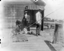
| Date: | 1899 |
|---|---|
| Description: | A young Syl fishing with three other adults off a pier using cane poles. |
| Date: | 07 07 1898 |
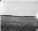
|---|---|
| Description: | View across water of Sturgeon Bay. In the far distance are lighthouses, buildings, and barges along the shoreline. |

| Date: | 1872 |
|---|---|
| Description: | This 1872 map shows the proposed route of a canal between Sturgeon Bay, on the Green Bay side of the Door Peninsula, and Lake Michigan. Depths in both Stur... |

| Date: | 1860 |
|---|---|
| Description: | This map of Dodge County, Wisconsin, shows the township and range grid, towns, sections, cities and villages, railroads, roads, property owners and acreage... |

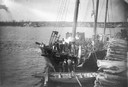
| Date: | 1895 |
|---|---|
| Description: | Seven men, standing informally, some wearing “yachting caps”, on a dock, presumably in Sturgeon Bay, Wis. |
If you didn't find the material you searched for, our Library Reference Staff can help.
Call our reference desk at 608-264-6535 or email us at:
