Filter: Categories of Wisconsin Historical Images
Filter: Subject of Water
Filter: County of Ashland
Filter: Categories of Wisconsin Historical Images
Filter: Subject of Water
Filter: County of Ashland

| Date: | 1988 |
|---|---|
| Description: | Congressman David Obey and his wife Joan on Martin Hanson's pontoon. He was a good friend of the Obeys and was inducted into the Wisconsin Conservation Hal... |

| Date: | 06 1923 |
|---|---|
| Description: | Sanborn map of Ashland, which includes Chequamegon Bay. |
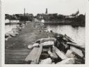
| Date: | 09 14 1962 |
|---|---|
| Description: | View from pier, lined with rocks, towards town. There are industrial buildings along the shoreline, and up a small rise is a building with a tower, and on ... |
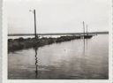
| Date: | 09 14 1962 |
|---|---|
| Description: | View across water towards jetty and dock, with three lampposts, from south east. |
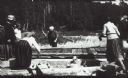
| Date: | 1915 |
|---|---|
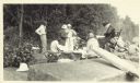
| Description: | Group of people setting up for a picnic on a beach at Apostle Island. |
| Date: | |
|---|---|
| Description: | Group of people at a picnic on the shoreline at Bass Island. Names written on back of print: Mrs. Abernathy, chair; Mrs. Hull; Mrs. Baker. |
| Date: | 1913 |
|---|---|
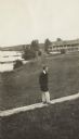
| Description: | Jesse Stone walking on board sidewalk, with the Mission Inn along the shoreline in the background. |
| Date: | 1920 |
|---|---|
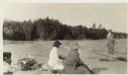
| Description: | View of Mrs. Cora Hull and Mrs. Julia Wood sitting on the beach at a shoreline. A man stands near the water. In the background are trees. |
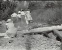
| Date: | 08 22 1916 |
|---|---|
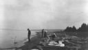
| Description: | View along shoreline towards people at a Bear Island picnic. A man stands near the water, and two women and a another man are among the logs along the shor... |

| Date: | 1915 |
|---|---|
| Description: | This map shows school houses, churches, farms, and railroads. Chequamecon Bay and Bad River Indian Reservation are labeld. The map reads: "All lands shown ... |

| Date: | 1909 |
|---|---|
| Description: | This map shows vacant Wisconsin Central Ry. lands, settlers houses, lands sold by Wisconsin Central Ry., schools, churches, saw mills, and roads; also show... |

| Date: | 1886 |
|---|---|
| Description: | This map shows north and south ore veins, landownership, railroads, rivers, and township grid in parts of Ashland County, Wis. and Ontonagon County, Mich. ... |

| Date: | 1910 |
|---|---|
| Description: | This map shows the locations of school houses, farms, roads, railroads, and Bad River Indian Reservation. Relief is shown by hachures. Yellow and red manus... |
If you didn't find the material you searched for, our Library Reference Staff can help.
Call our reference desk at 608-264-6535 or email us at: