 Filter: Categories of Wisconsin Historical Images
Filter: Subject of Water
Filter: County of Ashland
Filter: Categories of Wisconsin Historical Images
Filter: Subject of Water
Filter: County of Ashland

| Date: | 1977 |
|---|---|
| Description: | This pictorial map was produced by the Chateau, a resort in La Pointe, and shows Madeline Island landmarks and tourist attractions. On the verso is the spr... |

| Date: | 1990 |
|---|---|
| Description: | This tourism brochure of Ashland County, Wisconsin, from the Ashland Area Chamber of Commerce includes a map of the county showing tourist destinations and... |

| Date: | 1886 |
|---|---|
| Description: | This map of Ashland County, Wisconsin, which at the time included part of present-day Iron County, also covers portions of Vilas County, Wisconsin, then pa... |

| Date: | 1890 |
|---|---|
| Description: | This 1890s map shows the Wisconsin Central Railroad land grant lands owned and for sale by the Soo Line in Ashland County, Wisconsin, as well as in the eas... |
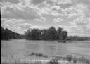
| Date: | 1935 |
|---|---|
| Description: | View from shoreline of men fishing out of wooden rowboats on the Flambeau River below the flowage dam. One man is standing in the river. A shack is visible... |

| Date: | 1900 |
|---|---|
| Description: | This chart of the northern Apostle Islands and Lake Superior shoreline shows relief by contours and spot heights and depths by contours, gradient tints and... |

| Date: | 1964 |
|---|---|
| Description: | This 1964 map of Madeline Island, Ashland County, Wisconsin, shows existing and historical locations, roads, the boundaries of a proposed state park, secti... |

| Date: | 1908 |
|---|---|
| Description: | Title at top: "G.F. Sanborn Company Timber and Farming Lands." Map shows acreages, roads, railroads, and swamps in parts of Vilas and Oneida counties. |

| Date: | 1850 |
|---|---|
| Description: | Map is pen and pencil on paper. The map shows roads, creeks, and the Chequamegon Bay. The map is undated and prepared sometime between the establishment of... |
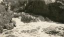
| Date: | 1931 |
|---|---|
| Description: | A group of people stand on a ledge overlooking Copper Falls. |

| Date: | 09 04 1885 |
|---|---|
| Description: | Exterior and interior bill of fare from The Chequamegon, with views on the back of rock formations, waterfalls, a spot illustration of a train going over a... |
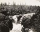
| Date: | |
|---|---|
| Description: | Elevated view of Copper Falls on the Bad River. Four people, one man and three women, are posing on rocks at the top of the falls. Surrounding burned-over ... |

| Date: | |
|---|---|
| Description: | View through trees of Copper Falls, on the Bad River. |
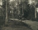
| Date: | |
|---|---|
| Description: | Dr. W.T. Rinehart, a prominent Ashland physician and surgeon, with Mrs. Rinehart and a sister, in an automobile crossing a small log bridge, probably over ... |

| Date: | 1951 |
|---|---|
| Description: | This map shows Ashland and Washburn harbors in shades of blue and yellow. Water depths shown by isolines and soundings, and relief is shown by contours. Th... |

| Date: | 1888 |
|---|---|
| Description: | This map shows wards and includes the Chequamegon Bay and Washburn. An inset map shows the Ashland region, its railroads, and a few of its iron mines. |

| Date: | 1916 |
|---|---|
| Description: | This map shows Chequamegon Bay, an inlet of Lake Superior. Depths are shown by isolines and soundings and relief shown by contours. The map is colored in y... |

| Date: | 1900 |
|---|---|
| Description: | This map is shows land in white and water in blue and is indexed for parks, points of interest, schools, churches, and recreational areas. The map shows lo... |

| Date: | 1924 |
|---|---|
| Description: | This map is pen, pencil, and watercolor on paper and shows land ownership by name, local streets, railroads, and part of Chequamegon Bay. The map includes ... |

| Date: | 1900 |
|---|---|
| Description: | This map is pencil and ink on tracing cloth and shows local streets, railroads, harbor line, and part of Chequamegon Bay. |
If you didn't find the material you searched for, our Library Reference Staff can help.
Call our reference desk at 608-264-6535 or email us at: