 Filter: Categories of Wisconsin Historical Images
Filter: Subject of Water
Filter: County of Ashland
Filter: Subject of streams
Filter: Categories of Wisconsin Historical Images
Filter: Subject of Water
Filter: County of Ashland
Filter: Subject of streams
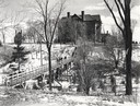
| Date: | 1955 |
|---|---|
| Description: | Wheeler Hall at Northland College, during winter. A group of people are on a bridge over the Bay City Creek, surrounded by trees, in the foreground. Wheele... |

| Date: | 1887 |
|---|---|
| Description: | This 1887 map of Ashland County, Wisconsin, shows the township and range system, sections, railroads, vacant Wisconsin Central Railroad land, state and "go... |

| Date: | 1896 |
|---|---|
| Description: | This 1898 map shows the township and range system, sections, cities and villages, railroads, roads, vacant land and land sold by the Wisconsin Central Rail... |

| Date: | 1925 |
|---|---|
| Description: | This 1925 map of Ashland County, Wisconsin, shows the township and range system, towns, sections, cities and villages, the Bad River Indian Reservation, ra... |

| Date: | 1890 |
|---|---|
| Description: | This map shows the Wisconsin Central Railroad land grant lands owned and for sale by the Soo Line in Ashland County, Wisconsin, as well as in portions of B... |

| Date: | 1886 |
|---|---|
| Description: | This map of Ashland County, Wisconsin, which at the time included part of present-day Iron County, also covers portions of Vilas County, Wisconsin, then pa... |

| Date: | 1890 |
|---|---|
| Description: | This 1890s map shows the Wisconsin Central Railroad land grant lands owned and for sale by the Soo Line in Ashland County, Wisconsin, as well as in the eas... |

| Date: | 1850 |
|---|---|
| Description: | Map is pen and pencil on paper. The map shows roads, creeks, and the Chequamegon Bay. The map is undated and prepared sometime between the establishment of... |
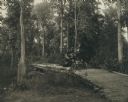
| Date: | |
|---|---|
| Description: | Dr. W.T. Rinehart, a prominent Ashland physician and surgeon, with Mrs. Rinehart and a sister, in an automobile crossing a small log bridge, probably over ... |
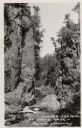
| Date: | 1950 |
|---|---|
| Description: | View of the Copper Canyon and the stream running through it. |
If you didn't find the material you searched for, our Library Reference Staff can help.
Call our reference desk at 608-264-6535 or email us at: