 Filter: Categories of Wisconsin Historical Images
Filter: Subject of Water
Filter: Community of New York City
Filter: Categories of Wisconsin Historical Images
Filter: Subject of Water
Filter: Community of New York City
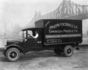
| Date: | 07 05 1927 |
|---|---|
| Description: | Driver in an International delivery truck parked along the waterfront with the Queensboro Bridge in the background. The truck was owned by Joseph Victori &... |

| Date: | 1969 |
|---|---|
| Description: | A large puddle in a parking lot where two automobiles, a Corvair and a Volkswagen, are parked. |

| Date: | |
|---|---|
| Description: | View of the S.S. "Nerissa" ocean liner in the water near New York City. the ship features a large smokestack, two masts and several flags. |

| Date: | |
|---|---|
| Description: | View of the "Queen of Bermuda" ocean liner in the water near New York City. The large ship features three large smokestacks, two masts, and many lifeboats.... |

| Date: | |
|---|---|
| Description: | Elevated view of the "Queen Mary" ocean liner in port. The large ship features three large smokestacks, two masts and lifeboats. "Queen ary" is painted on ... |

| Date: | |
|---|---|
| Description: | View across water toward the "Hendrick Hudson" excursion boat near New York City. Many passengers are on the large excursion boat's three decks. The boat a... |

| Date: | |
|---|---|
| Description: | View of the "Russell 5" tugboat in the water near New York City. An American flag is flying on the boat. "Russell 5" is painted on the vessel. The shorelin... |

| Date: | 03 1777 |
|---|---|
| Description: | Map showing the British and Hessian attack on Fort Washington in November of 1776. The movements and fortifications of the British and Hessian troops appea... |

| Date: | 1789 |
|---|---|
| Description: | Map of New York City showing ward boundaries, ferries, streets, roads, swamps, ponds, and rivers. The properties of Lispinard, Byards, Jones, Rutgers, and ... |

| Date: | 1776 |
|---|---|
| Description: | Fairly detailed map of New York City and parts of Long Island. It shows streets, roads, wharves, ferries, ship yards, Fort George and the battery, public b... |
If you didn't find the material you searched for, our Library Reference Staff can help.
Call our reference desk at 608-264-6535 or email us at: