 Filter: Categories of Wisconsin Historical Images
Filter: Subject of Water
Filter: Community of Madison
Filter: Categories of Wisconsin Historical Images
Filter: Subject of Water
Filter: Community of Madison

| Date: | 1839 |
|---|---|
| Description: | This map shows the hydrology of Madison and its vicinity at the height of interest in a proposed Milwaukee and Rock River Canal. It was made by Thomas Jeff... |

| Date: | 1839 |
|---|---|
| Description: | A map of the Wiskonsin [sic] and Neenah or Fox Rivers. |

| Date: | 1832 |
|---|---|
| Description: | Hand-drawn map in two parts of the route of Governor J.D. Doty. Probably made by Doty in 1832 as a result of his travels with Alexander J. Center. |

| Date: | 1910 |
|---|---|
| Description: | Map of the general plan of the district of the Four Lakes. |
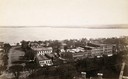
| Date: | 1899 |
|---|---|
| Description: | View along shoreline of University of Wisconsin-Madison buildings across Lake Mendota from Carroll Street. The Armory (Red Gym or Old Red), a boathouse, an... |

| Date: | 1950 |
|---|---|
| Description: | Aerial view of the Frank Lloyd-Wright-dsigned Unitarian Church under construction and the Veteran's Administration Hospital, also under construction, to th... |
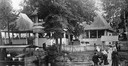
| Date: | |
|---|---|
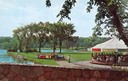
| Description: | View from a stone bridge towards Vilas Park, with children riding the carousel (merry-go-round) and a kiddie train adjacent to the lagoon. |
| Date: | 1915 |
|---|---|
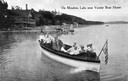
| Description: | View of a group of people in a large model launch with an American flag. Caption reads: "On Mendota Lake near University of Wisconsin-Madison Boat House." |
| Date: | 1904 |
|---|---|
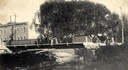
| Description: | View across Yahara River towards a group of people on the Sherman Avenue Bridge, with the old malt house in the background. |
| Date: | 1906 |
|---|---|
| Description: | View of Madison from Lake Monona with the Wisconsin State Capitol building in the background. This view of Brittingham Park shows a part of the park shortl... |
| Date: | 1907 |
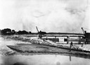
|---|---|
| Description: | A steam-powered dredge anchored in Monona Bay is filling in Brittingham Park. |

| Date: | 1904 |
|---|---|
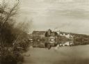
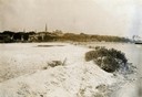
| Description: | Monona Bay from the railroad trestle looking southwest, close to where the railroad tracks cross North Shore Drive, (now Brittingham Park), with old houses... |

| Date: | 1897 |
|---|---|
| Description: | A view from the capitol looking west up State Street toward the University of Wisconsin-Madison with the Holy Redeemer Church, Holy Redeemer School, Red Gy... |
| Date: | 1890 |
|---|---|
| Description: | Looking south from the capitol dome of the Wisconsin State Capitol, the view is of West Main Street bound by South Hamilton Street and Monona Avenue (now M... |
| Date: | 1880 |
|---|---|
| Description: | Monona Lake Assembly, The Casino. This structure, including the ice house and provision space, designed by Conover and Porter and built for $1700.00 in Jun... |
| Date: | 1885 |
|---|---|
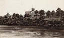
| Description: | Illustration of the exterior of the tourist resort Tonyawatha Spring Hotel (an earlier version was called Tonyawatha House) from across Lake Monona. There ... |
| Date: | 03 09 1878 |
|---|---|
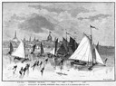
| Description: | Illustration by N.A. Greenback of ice-skaters and iceboats featuring the new Poughkeepsie design of pivoting runners. A key at the bottom of the image iden... |

| Date: | 1879 |
|---|---|
| Description: | Bird's-eye view of Wisconsin State University, now the University of Wisconsin-Madison. Vignettes include Ladies Hall, South Dormitory, University Hall, As... |
| Date: | 1912 |
|---|---|
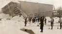
| Description: | Men harvesting ice at the Conklin Ice House on Lake Mendota. The men are using pike poles to slide the blocks to the conveyor and U-shaped tools to split p... |

| Date: | 1867 |
|---|---|
| Description: | Bird's-eye map of Madison with insets of the University, Rasdall House, Vilas House, and the Wisconsin State Capitol. View includes cattail marsh, smokesta... |
If you didn't find the material you searched for, our Library Reference Staff can help.
Call our reference desk at 608-264-6535 or email us at: