 Filter: Categories of Wisconsin Historical Images
Filter: Subject of Water
Filter: Community of Green Bay
Filter: Categories of Wisconsin Historical Images
Filter: Subject of Water
Filter: Community of Green Bay

| Date: | 1907 |
|---|---|
| Description: | Sanborn map of Green Bay featuring Elm, Cedar and Main Streets. |

| Date: | 1900 |
|---|---|
| Description: | This photostat map was probably originally created in 1835 and shows in addition to private claims, mills, roads, and trails. Green Bay and the Fox River a... |

| Date: | 1900 |
|---|---|
| Description: | This photocopied map shows private claim owners, buildings, and land use in 1818. Insets show Fort Howard and the caption reads: "A view of the Fox River ... |

| Date: | 1921 |
|---|---|
| Description: | This map shows various zones in a proposed city ordinance. Also shown are creeks, streets, parks, hospitals, cemeteries, and the Fox River. A legend is inc... |

| Date: | 1862 |
|---|---|
| Description: | This map shows landownership on a military reserve, private claims, buildings (including Fort Howard and U.S. sawmill), swamps, public barns and fields, an... |

| Date: | 1960 |
|---|---|
| Description: | This map is a facsimile of a 1829 map and shows private land claims, landowners within military reserve boundaries, sawmill, Fort Howard, public barns, bri... |

| Date: | 04 11 1940 |
|---|---|
| Description: | This blue line print map shows survey monument markers by type and industrial buildings and covers part of the lower Fox River and East River. The map incl... |

| Date: | 1850 |
|---|---|
| Description: | This map shows the location of planned blocks and lot numbers, street names, and docks along the Fox River and canal. |

| Date: | 1917 |
|---|---|
| Description: | View over the wing of a Lawson Military Tractor 2 (MT2) in flight. Below are houses and what may be a river or lake. Location is unknown, but is probably n... |

| Date: | 1917 |
|---|---|
| Description: | Photographic postcard of a view under the wing of a Lawson Military Tractor 2 (MT2) in flight. Below is a field and beyond are buildings and a body of wate... |

| Date: | 1835 |
|---|---|
| Description: | Map shows the Fox River, lot and block numbers, private claims, streets, a public squares, a manual labour school, and Fort Howard. An inset map shows a pl... |

| Date: | 1900 |
|---|---|
| Description: | This set of maps contains four sheets: "Landownership in the Vicinity of Military Reserve and Fort Howard," "Houses Along the River Road to Green Bay," "Ow... |

| Date: | 1919 |
|---|---|
| Description: | Exterior view from field across pond towards Alfred Lawson's aircraft plant, with buildings and smokestacks. Men are working with a pile of lumber on the l... |
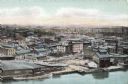
| Date: | |
|---|---|
| Description: | Aerial view of Green Bay from the bay. Commercial and industrial buildings are in the foreground. Waterfront businesses include F. Hurlbut Cement and W.W. ... |
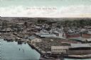
| Date: | |
|---|---|
| Description: | Bird's-eye view of Green Bay from the waterfront, with commercial buildings and factories. Caption reads: "Bird's Eye View, Green Bay, Wis." |
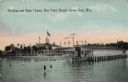
| Date: | 1918 |
|---|---|
| Description: | The pavilion and bath house at Bay View Beach. Bathers are walking in the shallow water in the foreground. Caption reads: "Pavilion and Bath House, Bay Vie... |
| Date: | |
|---|---|
| Description: | Aerial view of Green Bay, and the Fox River headed toward the bay. Commercial and industrial buildings are on the right bank, and residential neighborhoods... |

| Date: | |
|---|---|
| Description: | Elevated view of the Fox River at Green Bay. Warehouses and factories are along the riverfront, and a drawbridge is spanning the river in the background. |
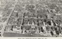
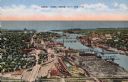
| Date: | 1956 |
|---|---|
| Description: | Caption reads: "Aerial View, Downtown Section, Green Bay, Wis." Text on reverse reads: "This aerial view shows the downtown district of the east side of ... |
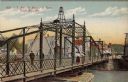
| Date: | |
|---|---|
| Description: | Illustrated postcard of an iron bridge over the Fox River with pedestrians crossing. The street on the far side is lined with businesses. Caption reads: "E... |
If you didn't find the material you searched for, our Library Reference Staff can help.
Call our reference desk at 608-264-6535 or email us at: