 Filter: Categories of Wisconsin Historical Images
Filter: Subject of War
Filter: Subject of transportation, military
Filter: Subject of water
Filter: Categories of Wisconsin Historical Images
Filter: Subject of War
Filter: Subject of transportation, military
Filter: Subject of water
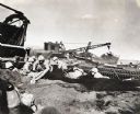
| Date: | 1945 |
|---|---|
| Description: | Marines use an International TD-18 Diesel crawler tractor (TracTracTor) to pull an ammunition trailer from the mud. The original caption reads: "JAPANESE A... |
| Date: | 1945 |
|---|---|
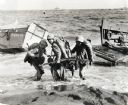
| Description: | Three marines dressed in uniform, carrying packs and holding guns, pull an ammunition cart through the water towards the beach at Iwo Jima. Military boats ... |
| Date: | 1945 |
|---|---|
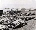
| Description: | Marines, killed in action, lie on stretchers covered with ponchos on the beach at Iwo Jima. Four marines attend to the dead. Tents, military boats, and an ... |
| Date: | 02 19 1945 |
|---|---|
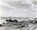
| Description: | Marines on the beach and military boats, including an LSM 242, in the water at Iwo Jima. |
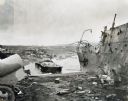
| Date: | 1945 |
|---|---|
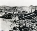
| Description: | Parts of destroyed boats and military equipment on the shoreline of Iwo Jima on D-Day. |
| Date: | 1945 |
|---|---|
| Description: | Marines dig foxholes into the sand on the beaches of Iwo Jima. The men are surrounded by military equipment, including a crane. An International Diesel cra... |
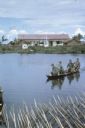
| Date: | 06 1962 |
|---|---|
| Description: | U.S. Army advisor Major M.C. Curley and soldiers crossing a river in the delta region of Vietnam in a small boat to visit an outpost. A large building, a m... |
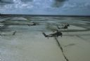
| Date: | 1962 |
|---|---|
| Description: | Aerial view of four U.S. Marine helicopters banking over an expanse of rice paddies in Vietnam. Fluffy white clouds fill the sky. |

| Date: | 11 1961 |
|---|---|
| Description: | Sea Swallows, an anti-communist Vietnamese militia, begin an operation by boats on a canal in the vicinity of Van Dinh, Vietnam. Militia members hold guns ... |

| Date: | 06 1962 |
|---|---|
| Description: | Aerial view of old U.S. Army model H-21 helicopter, assigned to help Vietnamese forces fight the Viet Cong in the mountain region of Vietnam. The patchwork... |

| Date: | 1758 |
|---|---|
| Description: | Map showing lakes, rivers, cities, Native American land, and the boundaries of French and English claims in America and Canada north of New York. A title c... |

| Date: | 1780 |
|---|---|
| Description: | Detailed topographical and political map of the area from Lake Champlain to Albany and the Hudson River. Relief is shown through hachures. The map shows ci... |
If you didn't find the material you searched for, our Library Reference Staff can help.
Call our reference desk at 608-264-6535 or email us at: