 Filter: Categories of Wisconsin Historical Images
Filter: Subject of War
Filter: Subject of shorelines
Filter: Subject of transportation
Filter: Categories of Wisconsin Historical Images
Filter: Subject of War
Filter: Subject of shorelines
Filter: Subject of transportation

| Date: | 1852 |
|---|---|
| Description: | Illustration of the Ojibwa, the Sacs, and Foxes battling from canoes on the water. |
| Date: | 07 16 1864 |
|---|---|
| Description: | Illustration from Frank Leslie's Illustrated Newspaper depicting Admiral Porter's fleet passing through Colonel Bailey's dam during the War on Red R... |
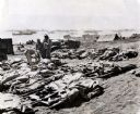
| Date: | 1945 |
|---|---|
| Description: | Marines, killed in action, lie on stretchers covered with ponchos on the beach at Iwo Jima. Four marines attend to the dead. Tents, military boats, and an ... |

| Date: | 06 1962 |
|---|---|
| Description: | U.S. Army advisor Major M.C. Curley and soldiers crossing a river in the delta region of Vietnam in a small boat to visit an outpost. A large building, a m... |
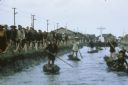
| Date: | 1962 |
|---|---|
| Description: | Canal in Binh Hung Vietnam with numerous small boats and a crowd of people walking alongside. In the background is a large cross and a number of large that... |

| Date: | 1944 |
|---|---|
| Description: | Continental Transportation Lines, Inc. operating an International semi-truck (tractor-trailer) on a road with a hazy view of a bridge, a body of water and ... |

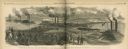
| Date: | 1920 |
|---|---|
| Description: | Aerial view looking over railroad cars on railroad tracks towards an encampment. Signs on a building at the encampment read: "War Exposition," and "Three M... |

| Date: | 1920 |
|---|---|
| Description: | Aerial view looking over railroad cars on railroad tracks towards an encampment. Sign on a building at the encampment reads: "War Exposition." A large crow... |

| Date: | 1920 |
|---|---|
| Description: | Aerial view looking over railroad cars on railroad tracks towards an encampment. Signs on a building at the encampment read: "War Exposition," and "Three M... |

| Date: | 1920 |
|---|---|
| Description: | Aerial view looking over railroad cars on railroad tracks towards an encampment. Signs on a building at the encampment read: "War Exposition," and "Three M... |

| Date: | 10 1776 |
|---|---|
| Description: | Broadside map showing the British invasion of New York city in August and September of 1776. The map shows important cities, forts, roads, hills, mountains... |

| Date: | 1781 |
|---|---|
| Description: | Map of the southern portion of the Chesapeake Bay and surrounding lands. It shows counties, a few cities and towns, forts, roads, islands, topographical fe... |
If you didn't find the material you searched for, our Library Reference Staff can help.
Call our reference desk at 608-264-6535 or email us at: