 Filter: Categories of Wisconsin Historical Images
Filter: Subject of War
Filter: Subject of military bases
Filter: Categories of Wisconsin Historical Images
Filter: Subject of War
Filter: Subject of military bases
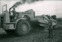
| Date: | 1967 |
|---|---|
| Description: | Two men use an International 270 pay scraper while completing construction work at Phan Rang, a South Vietnam air base. |
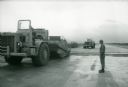
| Date: | 1967 |
|---|---|
| Description: | A man stands beside an International 270 pay scraper at Phan Rang, an air base in South Vietnam. |

| Date: | 06 1962 |
|---|---|
| Description: | Gift cows at the U.S. Marine Helicopter base in Soc Trang, Vietnam. Military and civilian men stand posing in a group in a field. Two of the men hold the r... |

| Date: | 1777 |
|---|---|
| Description: | Map of Colonial America east of Lake Michigan showing regions, cities, forts, Native American land, mountains, lakes, and rivers. Crossed swords and small ... |

| Date: | 1760 |
|---|---|
| Description: | Map showing upstate New York, Lake Ontario, and the St. Lawrence River during the last, decisive battle of the French and Indian War. The main map shows a ... |

| Date: | 1780 |
|---|---|
| Description: | Detailed topographical and political map of the area from Lake Champlain to Albany and the Hudson River. Relief is shown through hachures. The map shows ci... |

| Date: | 10 1776 |
|---|---|
| Description: | Broadside map showing the British invasion of New York city in August and September of 1776. The map shows important cities, forts, roads, hills, mountains... |

| Date: | 1781 |
|---|---|
| Description: | Map of the southern portion of the Chesapeake Bay and surrounding lands. It shows counties, a few cities and towns, forts, roads, islands, topographical fe... |
If you didn't find the material you searched for, our Library Reference Staff can help.
Call our reference desk at 608-264-6535 or email us at: