 Filter: Categories of Wisconsin Historical Images
Filter: Subject of War
Filter: Subject of land
Filter: Subject of battles
Filter: Categories of Wisconsin Historical Images
Filter: Subject of War
Filter: Subject of land
Filter: Subject of battles
| Date: | |
|---|---|
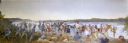
| Description: | Painting by Cal Peters depicting the battle of Bad Axe, also known as the Bad Axe massacre, at the Mississippi River on August 2, 1832. |

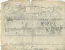
| Date: | 1852 |
|---|---|
| Description: | Illustration of the Ojibwa, the Sacs, and Foxes battling from canoes on the water. |
| Date: | 1889 |
|---|---|
| Description: | Stereograph from the Chicago Panorama of the Battle of Gettysburg Representing Pickett's Charge at 4 P.M., July 3rd, 1863: 69th Pennsylvania in Flank Attac... |
| Date: | 1889 |
|---|---|
| Description: | Stereograph from the Panorama of the Battle of Missionary Ridge, Colonel Randall L. Gibson and 13th Georgia Regiment, painted in 1885. It was painted by Eu... |
| Date: | 1889 |
|---|---|
| Description: | Stereograph from the Panorama of the Battle of Missionary Ridge, Capture of the Gun, "Lady Breckenridge," painted in 1885. It was painted by Eugen Bracht's... |

| Date: | 1889 |
|---|---|
| Description: | Stereograph from the Panorama of the Battle of Missionary Ridge, Confederate "Star Fort," General Sheridan in Foreground, painted in 1885. It was painted b... |
| Date: | 1889 |
|---|---|
| Description: | Stereograph from the Panorama of the Battle of Missionary Ridge, Confederate Fortifications, General Sheridan's Horses in Road, painted in 1885. It was pai... |
| Date: | 1889 |
|---|---|
| Description: | Stereograph from the Panorama of the Battle of Missionary Ridge, Historical Sycamore Tree, Orchard Knob in the Distance, painted in 1885. It was painted by... |
| Date: | 10 03 1862 |
|---|---|
| Description: | "Combined Confederate attack upon [Batteries] Robinette and Davis the attack on Battery Robinette being defeated and that on Davis resulting in the defeat ... |
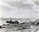
| Date: | 02 19 1945 |
|---|---|
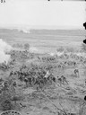
| Description: | Marines on the beach and military boats, including an LSM 242, in the water at Iwo Jima. |

| Date: | |
|---|---|
| Description: | A map of southern Wisconsin and northern Illinois showing where the battles took place and routes taken by Black Hawk and his band during the Black Hawk Wa... |
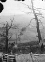
| Date: | 12 26 1943 |
|---|---|
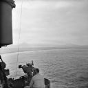
| Description: | Elevated view from aboard ship looking down on a soldier in a turret operating a range finder. These warships were participating in the heavy bombardment o... |

| Date: | 12 26 1943 |
|---|---|
| Description: | Navigation instruments on an American cruiser were checked by Lieutenant Commander Leonard Meyer of Appleton. Three other crew members are nearby. The crui... |
| Date: | 12 26 1943 |
|---|---|
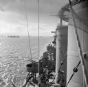
| Description: | Elevated view looking down towards deck of an American cruiser leaving the base heading for the bombardment of Cape Gloucester, New Britain, New Guinea (pr... |
| Date: | 12 26 1943 |
|---|---|
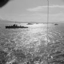
| Description: | Elevated view, perhaps from an American Cruiser, of warships leaving the base heading for the bombardment of Cape Gloucester, New Britain, New Guinea (pres... |

| Date: | 12 26 1943 |
|---|---|
| Description: | Seaman 2nd Class Jerry Burg (left) of Milwaukee, Wisconsin, and Seaman 2nd Class Harold Dawson of Toledo, Ohio, man the plane spotting station on an Americ... |
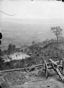
| Date: | 08 31 1944 |
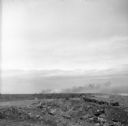
|---|---|
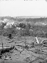
| Description: | Smoke rising from Cezembre Island, just north of Saint-Malo on the north coast of France. The island, which took a tremendous shelling, can barely be seen ... |

| Date: | 1740 |
|---|---|
| Description: | Engraved and hand-colored map of the Iberian peninsula as a theater of war during the War of the Spanish Succession (1701-1714). The map is dedicated to Ki... |

| Date: | 05 01 1899 |
|---|---|
| Description: | Map showing the Schuylkill River with roads, ferries, and points of interest from Valley Forge to Philadelphia, Pennsylvania as it appeared during the Revo... |

| Date: | 1777 |
|---|---|
| Description: | Map of Colonial America east of Lake Michigan showing regions, cities, forts, Native American land, mountains, lakes, and rivers. Crossed swords and small ... |
If you didn't find the material you searched for, our Library Reference Staff can help.
Call our reference desk at 608-264-6535 or email us at: