 Filter: Categories of Wisconsin Historical Images
Filter: Subject of War
Filter: Subject of hills
Filter: Categories of Wisconsin Historical Images
Filter: Subject of War
Filter: Subject of hills
| Date: | 10 03 1862 |
|---|---|
| Description: | "Combined Confederate attack upon [Batteries] Robinette and Davis the attack on Battery Robinette being defeated and that on Davis resulting in the defeat ... |
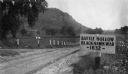
| Date: | 1927 |
|---|---|
| Description: | View of the Battle Hollow sign along an unpaved road. In the distance on the left is a rock formation covered with trees. Sign reads: "Battle Hollow Clack ... |

| Date: | 08 1957 |
|---|---|
| Description: | An Algerian National Liberation Front member on patrol, looking for enemy French forces. He is holding a rifle and wearing a turban and a tunic. Behind him... |
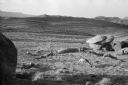
| Date: | 08 1957 |
|---|---|
| Description: | Algerian National Liberation Front members doing push-ups in the desert near boulders. |
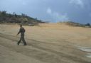
| Date: | 05 1961 |
|---|---|
| Description: | The wide dirt expanse of the Luang Prabang airport runway, Laos. A man is walking across a runway, and a plane is on another runway near a wooden building ... |
| Date: | 1961 |
|---|---|
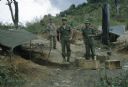
| Description: | Three Lao infantrymen stand outside near of tents in the Keukacham village. |

| Date: | 1961 |
|---|---|
| Description: | Small plane sitting on Keukacham airstrip, Laos. A green hill rises in the background and tents and ramshackle buildings are on either side of the strip. |

| Date: | 1961 |
|---|---|
| Description: | View of Keukacham village, Laos from behind a tank. A partially thatched building is in the foreground and other buildings on a dirt road are visible in th... |
| Date: | 1976 |
|---|---|
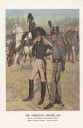
| Description: | "A general staff officer stands in the left foreground in the single-breasted blue coat with black herringbone false buttonholes on the chest and cuffs and... |

| Date: | 1780 |
|---|---|
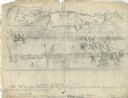
| Description: | Detailed topographical and political map of the area from Lake Champlain to Albany and the Hudson River. Relief is shown through hachures. The map shows ci... |

| Date: | 10 1776 |
|---|---|
| Description: | Broadside map showing the British invasion of New York city in August and September of 1776. The map shows important cities, forts, roads, hills, mountains... |
If you didn't find the material you searched for, our Library Reference Staff can help.
Call our reference desk at 608-264-6535 or email us at: