 Filter: Categories of Wisconsin Historical Images
Filter: Subject of Voyages and travels
Filter: Year of 1900-1999
Filter: Year of 1910-1919
Filter: Categories of Wisconsin Historical Images
Filter: Subject of Voyages and travels
Filter: Year of 1900-1999
Filter: Year of 1910-1919

| Date: | 1919 |
|---|---|
| Description: | This map depicts the route of the 1842 overland trip by wagon made by the Reverend Alfred Brunson and some copper miners from Prairie du Chien to the mouth... |
| Date: | 11 22 1919 |
|---|---|
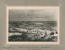
| Description: | Print on card depicting a herd of Bison near Lake Jessie. Written under the title is the date: "July 10th, 1853" and "Shyenne River County." |
| Date: | 1914 |
|---|---|
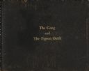
| Description: | The leather cover of the Pigeon River Journal, 1914, compiled by Howard Greene. The title "The Gang and The Pigeon Outfit" is stamped on the cover in gold. |
| Date: | 1914 |
|---|---|
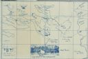
| Description: | A map, hand-drawn by Carl Greene, of the McFarland Lake (Minnesota) region. The map also includes several clever, humorous drawings referring to some membe... |
| Date: | 1916 |
|---|---|
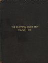
| Description: | The brown leather cover of Howard Greene's journal documenting a canoe trip down the Chippewa River. The title "The Chippewa River Trip, August-1916" is st... |
| Date: | 08 1916 |
|---|---|
| Description: | Two of The Gang (maybe Jack and Dad) canoeing homeward down the Chippewa River. |
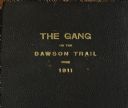
| Date: | 1911 |
|---|---|
| Description: | The brown leather cover of a journal compiled by Howard Greene. It is stamped in gold with the title "The Gang on the Dawson Trail, 1911." The actual Daws... |

| Date: | 1915 |
|---|---|
| Description: | The brown leather cover of Howard Greene's travel journal. The title, "Pack and Paddle from Tower to Ranier" is stamped on the leather in gold. |
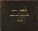
| Date: | 1910 |
|---|---|
| Description: | The brown leather cover of the journal of Howard Greene's Rainy Lake canoe trip. The title "The Gang in the Rainy Lake Region, 1910" is stamped onto the le... |
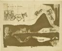
| Date: | 1910 |
|---|---|
| Description: | Carl Greene's drawing of a map of The Gang's trip to Winton, titled "We drive to Winton." This map shows a road currently known as the Thirteen Corners Roa... |
| Date: | 1910 |
|---|---|
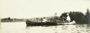
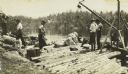
| Description: | The Gang standing on Fisherman's Dock on Fall Lake with their travel supplies at the beginning of their trip. Billy Mac is second from the left, and third ... |
| Date: | 1910 |
|---|---|
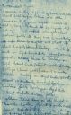
| Description: | Notes written by ranger J.B. MacDonald regarding routes for The Gang to follow. |
| Date: | 1910 |
|---|---|
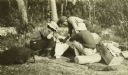
| Description: | The Gang is sitting on their packs or bedrolls as they consult their maps with a ranger. |
| Date: | 1910 |
|---|---|
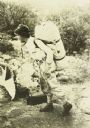
| Description: | Carl carrying a large pack on his back and holding a bag. He is wearing a beaded belt that was almost certainly made by an Indian. |
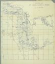
| Date: | 1911 |
|---|---|
| Description: | A map of St. Louis County, Minnesota that traces the route of Howard Green and The Gang's canoe trip from Tower to Ranier. |
If you didn't find the material you searched for, our Library Reference Staff can help.
Call our reference desk at 608-264-6535 or email us at: