 Filter: Categories of Wisconsin Historical Images
Filter: Subject of Voyages and travels
Filter: Subject of transportation
Filter: Categories of Wisconsin Historical Images
Filter: Subject of Voyages and travels
Filter: Subject of transportation

| Date: | 1925 |
|---|---|
| Description: | De Prorok's car, Sandy and all members of the expedition: Pond, Tyrrell, De Prorok, Martini, Denny, Reygasse, Chauffeur Barth, Chapuis, Belaid, and in fron... |

| Date: | 1836 |
|---|---|
| Description: | This map depicts Wisconsin and Michigan territories in 1836. It includes the area from Michigan to the Missouri River and Lake Winnipeg, and it shows the e... |
| Date: | 05 24 1820 |
|---|---|
| Description: | A page, headed with "Journal No. 1," of James Doty's journal of a trip with Cass, Schoolcraft, etc. to the sources of the Mississippi River. |

| Date: | 1938 |
|---|---|
| Description: | Advertisement for International trucks, featuring Commander Attilio Gatti and his wife with their "jungle yachts" in the "Belgian Congo." International mad... |

| Date: | 02 1823 |
|---|---|
| Description: | A map featuring the North American expedition from Pittsburgh to the Rocky Mountains led by Edwin James. |

| Date: | 1936 |
|---|---|
| Description: | This manuscript map shows the route traveled by the Schoolcraft expedition in July 1831 between the Namekagon River and Lake Owen in the Town of Cable, Bay... |
| Date: | |
|---|---|
| Description: | The fast movement was a nervous reach for something west. But along the way there was no hurry. Wait for noontime, turned round to a movement eastward,<... |
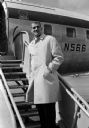
| Date: | 04 06 1960 |
|---|---|
| Description: | A man (Henry Derleth) wears an overcoat while posed on the middle of the boarding stairway attached to a partially visible passenger airliner. The original... |

| Date: | 1679 |
|---|---|
| Description: | Decorative and detailed map of the eastern half of North America. Regions, cities, colonies, Native America land, rivers, lakes and some nautical features ... |

| Date: | 1684 |
|---|---|
| Description: | Map of North America showing some colonies, cities, rivers, lakes, and Native American land. Ship routes spread across both oceans, including one decorated... |

| Date: | 1713 |
|---|---|
| Description: | Map showing the regions explored by Robert de La Salle between 1681 and 1686, as well as the route La Salle, and later Henri Joutel, took, moving north fro... |

| Date: | 1775 |
|---|---|
| Description: | This six sheet large format map is one of the most informative maps of its time. It shows cities, Native American land, lakes, rivers, mountains, topograph... |
| Date: | 1907 |
|---|---|
| Description: | View down shoreline towards the travelers pausing in their canoe journey to have lunch on the riverbank below Gordon Dam. |
| Date: | 1907 |
|---|---|
| Description: | The travelers, including Diadem, taking the ferry at Pansy. |
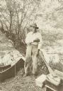
| Date: | 1907 |
|---|---|
| Description: | Bill Williams standing in front of a tree at the shoreline. There is a canoe next to him on the left, and paddles, bags and boxes are on the ground on the ... |
| Date: | 08 1916 |
|---|---|
| Description: | Two of The Gang (maybe Jack and Dad) canoeing homeward down the Chippewa River. |
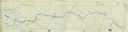
| Date: | 1909 |
|---|---|
| Description: | A cyanoprint map of The Gang's journey down the Presque Isle River. There are small drawings around the border depicting the adventures of The Gang and Car... |
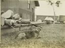
| Date: | 1909 |
|---|---|
| Description: | Carl Greene's dog Nimrod resting on the grass in Watersmeet. There is a chain on his collar, and The Gang's travel supplies, including a cased mandolin, ar... |
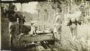
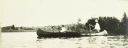
| Date: | 1909 |
|---|---|
| Description: | The Gang happens upon a mine push car at a mining site on Presque Isle. They are using the car to portage some of their supplies and gear. |
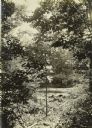
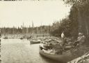
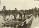
| Date: | 1909 |
|---|---|
| Description: | A view through foliage of the canoes at the Presque Isle River, where The Gang completed their first portage of the trip. |
If you didn't find the material you searched for, our Library Reference Staff can help.
Call our reference desk at 608-264-6535 or email us at: