 Filter: Categories of Wisconsin Historical Images
Filter: Subject of Voyages and travels
Filter: Subject of rivers
Filter: Year of 1900-1999
Filter: Categories of Wisconsin Historical Images
Filter: Subject of Voyages and travels
Filter: Subject of rivers
Filter: Year of 1900-1999

| Date: | 1919 |
|---|---|
| Description: | This map depicts the route of the 1842 overland trip by wagon made by the Reverend Alfred Brunson and some copper miners from Prairie du Chien to the mouth... |

| Date: | 1936 |
|---|---|
| Description: | This manuscript map shows the route traveled by the Schoolcraft expedition in July 1831 between the Namekagon River and Lake Owen in the Town of Cable, Bay... |

| Date: | 1905 |
|---|---|
| Description: | This pictorial representation of part of Lake Winnebago and the Fox River in 1703, showing interactions between white beaver hunters and the Iroquois is ta... |
| Date: | 1935 |
|---|---|
| Description: | Original created in 1788, this facsimile map shows the routes traveled by Perrault, an early voyageur in Northern America. |
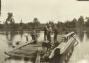
| Date: | 1907 |
|---|---|
| Description: | The travelers, including Diadem, taking the ferry at Pansy. |
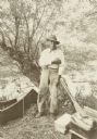
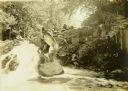
| Date: | 1907 |
|---|---|
| Description: | Bill Williams standing in front of a tree at the shoreline. There is a canoe next to him on the left, and paddles, bags and boxes are on the ground on the ... |
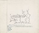
| Date: | 1914 |
|---|---|
| Description: | A map, hand-drawn by Carl Greene, of the McFarland Lake (Minnesota) region. The map also includes several clever, humorous drawings referring to some membe... |
| Date: | 08 1916 |
|---|---|
| Description: | Two of The Gang (maybe Jack and Dad) canoeing homeward down the Chippewa River. |
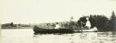
| Date: | 1909 |
|---|---|
| Description: | A view through foliage of the canoes at the Presque Isle River, where The Gang completed their first portage of the trip. |
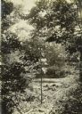
| Date: | 1909 |
|---|---|
| Description: | Two of The Gang carrying a canoe on a portage in the Presque Isle River. |

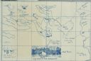
| Date: | 1909 |
|---|---|
| Description: | A hand-drawn and illustrated map of The Gang's trip from their seventh camp to Lake Superior. |
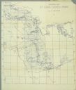
| Date: | 1911 |
|---|---|
| Description: | A map of St. Louis County, Minnesota that traces the route of Howard Green and The Gang's canoe trip from Tower to Ranier. |

| Date: | 12 1927 |
|---|---|
| Description: | View towards shoreline of people unloading at waterfront in African village. The truck is on a platform supported by four long boats. The far shoreline is ... |
If you didn't find the material you searched for, our Library Reference Staff can help.
Call our reference desk at 608-264-6535 or email us at: