 Filter: Categories of Wisconsin Historical Images
Filter: Subject of Voyages and travels
Filter: Subject of indians of north america
Filter: Categories of Wisconsin Historical Images
Filter: Subject of Voyages and travels
Filter: Subject of indians of north america
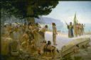
| Date: | 1904 |
|---|---|
| Description: | Jean Nicolet (1598-1642) was the first European to see Wisconsin and was a prominent French explorer who, for many years, lived among the Indians of Quebec... |
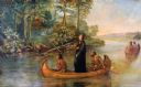
| Date: | 1921 |
|---|---|
| Description: | Painted scene of an Indian guide paddling, Jacques Marquette, a Jesuit missionary standing, and Louis Joliet, a fur trader paddling in a canoe exploring th... |

| Date: | 1893 |
|---|---|
| Description: | Front and back covers of an advertising brochure for the New Empire line of mowers, reapers and grain binders manufactured by J.F. Seiberling & Company. Th... |

| Date: | 1905 |
|---|---|
| Description: | This pictorial representation of part of Lake Winnebago and the Fox River in 1703, showing interactions between white beaver hunters and the Iroquois is ta... |

| Date: | 1790 |
|---|---|
| Description: | An updated and corrected version of Robert de Vaugondy's 1750 map "Amérique Septentrionale: Dressée sur les Relations les Plus Modernes des Voyageurs et Na... |

| Date: | 1679 |
|---|---|
| Description: | Decorative and detailed map of the eastern half of North America. Regions, cities, colonies, Native America land, rivers, lakes and some nautical features ... |

| Date: | 1684 |
|---|---|
| Description: | Map of North America showing some colonies, cities, rivers, lakes, and Native American land. Ship routes spread across both oceans, including one decorated... |

| Date: | 1775 |
|---|---|
| Description: | This six sheet large format map is one of the most informative maps of its time. It shows cities, Native American land, lakes, rivers, mountains, topograph... |
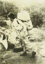
| Date: | 1910 |
|---|---|
| Description: | Carl carrying a large pack on his back and holding a bag. He is wearing a beaded belt that was almost certainly made by an Indian. |
If you didn't find the material you searched for, our Library Reference Staff can help.
Call our reference desk at 608-264-6535 or email us at: