 Filter: Categories of Wisconsin Historical Images
Filter: Subject of Voyages and travels
Filter: Creator Name of Unknown
Filter: Subject of water
Filter: Categories of Wisconsin Historical Images
Filter: Subject of Voyages and travels
Filter: Creator Name of Unknown
Filter: Subject of water

| Date: | 1823 |
|---|---|
| Description: | In 1823 U.S. Army major Stephen H. Long led an expedition of scientific, trade, and military investigation up the Mississippi River and the Red River of th... |
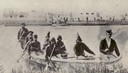
| Date: | 1860 |
|---|---|
| Description: | Nine men arrive at Fort William by canoe. Fort William, also called Kaministiguia, was the Hudson's Bay fur trading post. Men are standing along the opposi... |
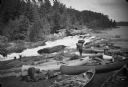
| Date: | |
|---|---|
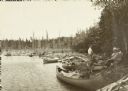
| Description: | View of men and young boys with canoes pulled up on rocks near a rapids during an unidentified wilderness canoe trip led by Sigurd Olson. |

| Date: | 02 1823 |
|---|---|
| Description: | A map featuring the North American expedition from Pittsburgh to the Rocky Mountains led by Edwin James. |
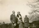
| Date: | 02 22 1930 |
|---|---|
| Description: | William Conrad Seipp, Jr., left, and his daughter Melita, far right, pose with Alma Schmidt Petersen and her son Conrad at an overlook above Portofino Bay.... |
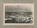
| Date: | 11 22 1919 |
|---|---|
| Description: | Print on card depicting a herd of Bison near Lake Jessie. Written under the title is the date: "July 10th, 1853" and "Shyenne River County." |
| Date: | 1907 |
|---|---|
| Description: | View down shoreline towards the travelers pausing in their canoe journey to have lunch on the riverbank below Gordon Dam. |
| Date: | |
|---|---|
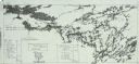
| Description: | A geological map of the Rainy Lake region in Minnesota and Ontario. |
| Date: | |
|---|---|
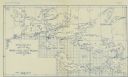
| Description: | A blueprint map with an overlay traced in pencil of the routes of Howard Greene and The Gang's 1910 and 1911 canoe trips. |
If you didn't find the material you searched for, our Library Reference Staff can help.
Call our reference desk at 608-264-6535 or email us at: