Filter: Categories of Wisconsin Historical Images
Filter: Subject of Valleys
Filter: Subject of trees
Filter: Categories of Wisconsin Historical Images
Filter: Subject of Valleys
Filter: Subject of trees

| Date: | 1760 |
|---|---|
| Description: | Map showing the towns, mountains, valleys, corn fields, and rivers of a portion of the Cherokee Nation. A few annotations on the map explain the land and r... |

| Date: | 1972 |
|---|---|
| Description: | Three-quarter view from front left of a man operating a TD-25 on the side of a hill. There is a valley in the background. Vecellio and Grogan, Inc., workin... |

| Date: | 1972 |
|---|---|
| Description: | Elevated view of men operating Pay Haulers and a Pay Loader at the top of a hill. Vecellio and Grogan, Inc., working on highway project cutting four and on... |

| Date: | 1914 |
|---|---|
| Description: | Elevated view across valley towards a pass in the Sawtooth Mountains, with a very tall, bare tree in the foreground. |

| Date: | 07 13 1925 |
|---|---|
| Description: | View down slope towards a tractor powering a sawmill in a forest. There is a valley and hills in the background. |

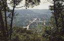
| Date: | 09 07 2014 |
|---|---|
| Description: | View from the top of a hill looking out to a valley, with clouds in the blue sky. Trees are framing the view, and in the foreground, a woman, the photograp... |

| Date: | 09 13 2014 |
|---|---|
| Description: | Shoveler's Sink, a small pond, sitting in a valley of small hills dotted with trees. Ducks are swimming in the lower left portion of the pond. |

| Date: | 03 24 2015 |
|---|---|
| Description: | View across snowy field towards a pond. |

| Date: | |
|---|---|
| Description: | Slightly elevated view of two young people riding the chair lift at a ski hill. |
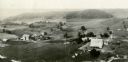
| Date: | 1930 |
|---|---|
| Description: | Aerial view of two farms, with fields and barns in a valley. This image appeared in Joseph Schafer's 1932 book The Wisconsin Lead Region, on a photo... |
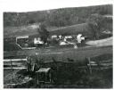
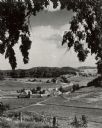
| Date: | 1897 |
|---|---|
| Description: | View down hill towards a farm in a valley, with wooded bluffs in the background. In the foreground, a fence is at the top of the hill overlooking the farm.... |
| Date: | 1950 |
|---|---|
| Description: | View down hill towards a farm in a valley, with harvested corn in corn shocks in the field. Tree-lined hills are in the background. Text on reverse of imag... |
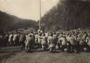
| Date: | 1914 |
|---|---|
| Description: | Sunday mass for Austrian soldiers, members of a "Tiroler Standschützen" unit, in South Tyrol during World War I. |
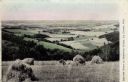
| Date: | |
|---|---|
| Description: | View from a hay field on a hill looking towards pastures and fields in a valley. Caption reads: "Harvest Scene in Bostwick Valley, La Crosse, Wis." |
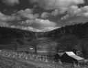
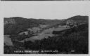
| Date: | 1945 |
|---|---|
| Description: | Elevated view of a large farm in a valley. Caption reads: "Prosperous Sauk County Dairy farm — nestling in a fertile valley between timber-clad hills. Phot... |
| Date: | |
|---|---|
| Description: | Photographic postcard view of a coulee landscape. Agricultural fields are on a hillside. Caption reads: "Coulee Scene near La Crosse, Wis." |

| Date: | 08 1925 |
|---|---|
| Description: | View from hill across a field towards a stream running along the base of a hillside. Caption reads: "U.S. H. 61, Crawford Co. Boscobel-Soldiers Gr. Road. M... |
If you didn't find the material you searched for, our Library Reference Staff can help.
Call our reference desk at 608-264-6535 or email us at: