Filter: Categories of Wisconsin Historical Images
Filter: Subject of Valleys
Filter: Subject of mississippi river
Filter: Categories of Wisconsin Historical Images
Filter: Subject of Valleys
Filter: Subject of mississippi river
| Date: | |
|---|---|
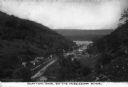
| Description: | An elevated view of the town of Clayton, Iowa, which is nestled in a valley. The Mississippi River can be seen nearby. Caption reads: "Clayton, Iowa, on th... |

| Date: | 1839 |
|---|---|
| Description: | This map shows the geological makeup of the valley in red, yellow, and green, the Mississippi River, and the location of Fort Crawford. The geology on the ... |

| Date: | 1760 |
|---|---|
| Description: | Map showing the towns, mountains, valleys, corn fields, and rivers of a portion of the Cherokee Nation. A few annotations on the map explain the land and r... |
If you didn't find the material you searched for, our Library Reference Staff can help.
Call our reference desk at 608-264-6535 or email us at: