 Filter: Categories of Wisconsin Historical Images
Filter: Subject of Valleys
Filter: Subject of intellectual life
Filter: Categories of Wisconsin Historical Images
Filter: Subject of Valleys
Filter: Subject of intellectual life

| Date: | 1958 |
|---|---|
| Description: | Aerial view of contour strip farming with the Obert Olstad farm in foreground. The Carl Backum farm is in the background. |

| Date: | 1882 |
|---|---|
| Description: | Bird's-eye views of various sections of Milwaukee. |

| Date: | 11 1951 |
|---|---|
| Description: | Aerial view of US Highway 14 southeast of La Crosse descending into Mormon Coulee. The original caption of the print, which is undated, describes the road ... |

| Date: | 1839 |
|---|---|
| Description: | This map shows the geological makeup of the valley in red, yellow, and green, the Mississippi River, and the location of Fort Crawford. The geology on the ... |

| Date: | 1760 |
|---|---|
| Description: | Map showing the towns, mountains, valleys, corn fields, and rivers of a portion of the Cherokee Nation. A few annotations on the map explain the land and r... |
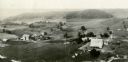
| Date: | 1930 |
|---|---|
| Description: | Aerial view of two farms, with fields and barns in a valley. This image appeared in Joseph Schafer's 1932 book The Wisconsin Lead Region, on a photo... |

| Date: | 1940 |
|---|---|
| Description: | Text on front reads: "Birdseye, Business Center, Richland Center, Wis." An aerial view, looking north, of the town situated between tree covered hills. The... |
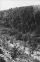
| Date: | 1950 |
|---|---|
| Description: | Text on front reads: "The Old Mill Stream in the Narrows at Rock Springs, Wis." A road and the Narrows Creek run next to each other in an elevated view of ... |

| Date: | 11 03 1903 |
|---|---|
| Description: | A drawing of a group of burial mounds in Linden Valley. Text on back reads: "These mounds lie at the narrow mouth of Linden Valley on the east side of the ... |
If you didn't find the material you searched for, our Library Reference Staff can help.
Call our reference desk at 608-264-6535 or email us at: