 Filter: Categories of Wisconsin Historical Images
Filter: Subject of University of Wisconsin
Filter: Subject of water
Filter: Subject of recreation areas
Filter: Categories of Wisconsin Historical Images
Filter: Subject of University of Wisconsin
Filter: Subject of water
Filter: Subject of recreation areas
| Date: | 05 26 1947 |
|---|---|
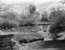
| Description: | Duck pond at the University of Wisconsin-Madison Arboretum, a favorite spot for Madison children where mallard ducks live year around. |
| Date: | 05 26 1947 |
|---|---|
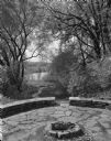
| Description: | The stone council circle in the University of Wisconsin-Madison Arboretum. It was built by noted landscape architect and bereaved father, Jens Jensen, as a... |

| Date: | 02 06 1948 |
|---|---|
| Description: | Aerial photograph of Madison's west side looking northeast along Speedway Road. Visible are Forest Hill and Resurrection Cemeteries, West High School, Hoyt... |

| Date: | 02 06 1948 |
|---|---|
| Description: | Aerial view of west side, looking south along Glenway Street. Visible are the reservoir, Lake Wingra, Forest Hill and Resurrection Cemetery, Hoyt Park. Maj... |

| Date: | 02 06 1948 |
|---|---|
| Description: | Looking north along Glenway Street. Visible are the reservoir, Hoyt and Quarry Parks, Resurrection and Forest Hill Cemeteries, Rentschler Greenhouses, Fore... |

| Date: | 02 06 1948 |
|---|---|
| Description: | Looking southeast across Speedway Road. Visible are the reservoir on Glenway Street, Hoyt Park, Resurrection and Forest Hill cemeteries, Glenway Golf cours... |
| Date: | 1905 |
|---|---|
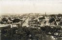
| Description: | Elevated view from the roof of the Wisconsin State Capitol looking west along State Street to Bascom Hall (with dome). The State Historical Society Buildin... |

| Date: | 1928 |
|---|---|
| Description: | Illustrated map of points of interest, including University buildings, parks, athletic venues, fraternity and sorority houses, and state buildings. |

| Date: | 07 1899 |
|---|---|
| Description: | Elevated view from hill of Picnic Point, located on the south shore of Lake Mendota. |

| Date: | 1914 |
|---|---|
| Description: | This map shows a plat of the town, city limits, numbered blocks and lots, wards, local streets, roads, railroads, Capitol Square, Vilas Park, Edgewood Acad... |

| Date: | 1956 |
|---|---|
| Description: | This map shows local streets, roads, railroads, highways, parks, cemeteries, hospitals, the University of Wisconsin, Middleton, Maple Bluff, Shorewood Hill... |

| Date: | 1971 |
|---|---|
| Description: | This map shows streets, highways, railroads, parks, colleges, cemeteries, county clubs, University of Wisconsin, Truax Field, Middleton, Shorewood Hills, M... |

| Date: | 1961 |
|---|---|
| Description: | This street map includes an ancillary map of Dane County highways and a business directory. Lake Mendota, Lake Monona, Monona Bay, Yahara River, and Lake W... |

| Date: | 2004 |
|---|---|
| Description: | This map shows ATMs, houses of worship, hotels, parking ramps, public parking, union cab stands, bus stops, business district, parks and public areas, gove... |
| Date: | 07 06 1955 |
|---|---|
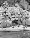
| Description: | Monkeys on monkey island at the Vilas Park Zoo. The monkeys are on loan from the University of Wisconsin during the summer and returned in the winter to be... |
| Date: | 08 10 1957 |
|---|---|
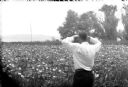
| Description: | Unidentified man taking a picture of the Lotus Bed on Lake Mendota. The bed of large, floating white blossoms are at the peak of their bloom. |
| Date: | 08 11 1960 |
|---|---|
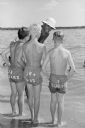
| Description: | Angello LaBarro, a lifeguard at a Madison beach, gives some advice to some junior aids while on duty. He is a graduate of Madison East high school and has ... |
If you didn't find the material you searched for, our Library Reference Staff can help.
Call our reference desk at 608-264-6535 or email us at: