 Filter: Categories of Wisconsin Historical Images
Filter: Subject of University of Wisconsin
Filter: Subject of recreation areas
Filter: Subject of human settlements
Filter: Categories of Wisconsin Historical Images
Filter: Subject of University of Wisconsin
Filter: Subject of recreation areas
Filter: Subject of human settlements
| Date: | |
|---|---|
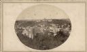
| Description: | John S. Fuller made this photograph of the three University buildings on Bascom Hill (then known as College Hill) from the Capitol roof about 1860. Grace E... |
| Date: | 1955 |
|---|---|
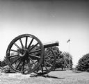
| Description: | Camp Randall Memorial Park cannon with an American flag flying in the background. |

| Date: | 04 28 1945 |
|---|---|
| Description: | Annual University of Wisconsin-Madison student work day project located at Picnic Point. Shown posing together are the chosen "blue jeans" king and queen f... |

| Date: | 02 06 1948 |
|---|---|
| Description: | Aerial photograph of Madison's west side looking northeast along Speedway Road. Visible are Forest Hill and Resurrection Cemeteries, West High School, Hoyt... |

| Date: | 02 06 1948 |
|---|---|
| Description: | Aerial view of west side, looking south along Glenway Street. Visible are the reservoir, Lake Wingra, Forest Hill and Resurrection Cemetery, Hoyt Park. Maj... |

| Date: | 02 06 1948 |
|---|---|
| Description: | Looking north along Glenway Street. Visible are the reservoir, Hoyt and Quarry Parks, Resurrection and Forest Hill Cemeteries, Rentschler Greenhouses, Fore... |

| Date: | 02 06 1948 |
|---|---|
| Description: | Looking southeast across Speedway Road. Visible are the reservoir on Glenway Street, Hoyt Park, Resurrection and Forest Hill cemeteries, Glenway Golf cours... |

| Date: | 09 24 1948 |
|---|---|
| Description: | Five children with one adult are shown playing on swings at Eagle Heights, a University of Wisconsin-Madison housing development built for faculty families... |

| Date: | |
|---|---|
| Description: | Located on the University of Wisconsin-Madison campus, the lane is a dirt path surrounded by trees. |

| Date: | 07 21 1949 |
|---|---|
| Description: | Mid-morning refreshments are an important part of the day for youngsters at the University Faculty Housing playground. Mrs. Harold Green pours a fruit drin... |
| Date: | 1905 |
|---|---|
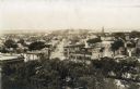
| Description: | Elevated view from the roof of the Wisconsin State Capitol looking west along State Street to Bascom Hall (with dome). The State Historical Society Buildin... |

| Date: | 07 1899 |
|---|---|
| Description: | Elevated view from hill of Picnic Point, located on the south shore of Lake Mendota. |

| Date: | 1956 |
|---|---|
| Description: | This map shows local streets, roads, railroads, highways, parks, cemeteries, hospitals, the University of Wisconsin, Middleton, Maple Bluff, Shorewood Hill... |

| Date: | 1971 |
|---|---|
| Description: | This map shows streets, highways, railroads, parks, colleges, cemeteries, county clubs, University of Wisconsin, Truax Field, Middleton, Shorewood Hills, M... |

| Date: | 1857 |
|---|---|
| Description: | Elevated view from the Wisconsin State Capitol up State Street to Bascom Hall. There is a fence around the capitol grounds, and pedestrians are walking on ... |

| Date: | 1961 |
|---|---|
| Description: | This street map includes an ancillary map of Dane County highways and a business directory. Lake Mendota, Lake Monona, Monona Bay, Yahara River, and Lake W... |

| Date: | 2004 |
|---|---|
| Description: | This map shows ATMs, houses of worship, hotels, parking ramps, public parking, union cab stands, bus stops, business district, parks and public areas, gove... |
If you didn't find the material you searched for, our Library Reference Staff can help.
Call our reference desk at 608-264-6535 or email us at: