 Filter: Categories of Wisconsin Historical Images
Filter: Subject of University of Wisconsin
Filter: Subject of landforms
Filter: Categories of Wisconsin Historical Images
Filter: Subject of University of Wisconsin
Filter: Subject of landforms

| Date: | 1940 |
|---|---|
| Description: | Aerial view looking east over the center of the city and the University of Wisconsin-Madison campus. |

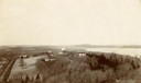
| Date: | 1908 |
|---|---|
| Description: | A panoramic aerial view of the Isthmus taken from a kite. Lake Mendota is to the right in the background with Picnic Point jutting into the lake. The photo... |

| Date: | 06 30 1926 |
|---|---|
| Description: | View across Observatory Drive, looking down towards the Van Hise dormitories: Adams, Tripp, and Carson Gulley Commons. Picnic Point is in the distance on L... |

| Date: | 12 1925 |
|---|---|
| Description: | Elevated view of the Van Hise Dormitories under construction: Adams, Tripp, Carson Gulley Commons, and a view of Picnic Point, at the University of Wiscons... |
| Date: | 1898 |
|---|---|
| Description: | Elevated view of Observatory Hill, Observatory Hall, the Agriculture Campus and Lake Mendota on the University of Wisconsin-Madison Campus. |
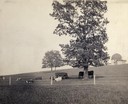
| Date: | 1900 |
|---|---|
| Description: | Fenced-in, the cattle find a grassy pasture of Observatory Hill below Washburn Observatory on the University of Wisconsin-Madison campus. |
| Date: | 1899 |
|---|---|
| Description: | View of home atop of Observatory Hill on the University of Wisconsin-Madison campus. |

| Date: | 1945 |
|---|---|
| Description: | View of the lower campus of the University of Wisconsin-Madison includes Bascom Hill, Wisconsin Historical Society, Memorial Union and the Armory (Red Gym ... |

| Date: | 1923 |
|---|---|
| Description: | Aerial view of the Wisconsin Historical Society, Science Hall, and Bascom Hall on Bascom Hill on the University of Wisconsin-Madison campus. Lake Mendota i... |
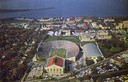
| Date: | 1963 |
|---|---|
| Description: | Aerial view of Camp Randall during a football game on the University of Wisconsin-Madison campus with Picnic Point in the background. |
| Date: | 1900 |
|---|---|
| Description: | Elevated view of Observatory Hill on the University of Wisconsin Madison campus of the United States National, Wisconsin State Farm Experiment Station, Pro... |

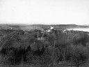
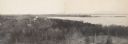
| Date: | 1924 |
|---|---|
| Description: | Aerial view of Madison's Willow Beach towards the University of Wisconsin-Madison campus, downtown Madison, and Lake Monona. |

| Date: | 07 06 1937 |
|---|---|
| Description: | Aerial view of the west central part of isthmus and the University of Wisconsin campus. |

| Date: | 1909 |
|---|---|
| Description: | View from the University of Wisconsin service building smokestack of south Madison, including Mills Street, Mound Street, and the Greenbush. Lake Monona is... |
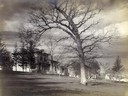
| Date: | |
|---|---|
| Description: | Panoramic photograph from top of Bascom Hall facing northwest, showing Picnic Point on the University of Wisconsin campus. Washburn Observatory visible to ... |

| Date: | 02 06 1948 |
|---|---|
| Description: | Aerial photograph of Madison's west side looking northeast along Speedway Road. Visible are Forest Hill and Resurrection Cemeteries, West High School, Hoyt... |

| Date: | 02 06 1948 |
|---|---|
| Description: | Aerial view of west side, looking south along Glenway Street. Visible are the reservoir, Lake Wingra, Forest Hill and Resurrection Cemetery, Hoyt Park. Maj... |

| Date: | 02 06 1948 |
|---|---|
| Description: | Looking north along Glenway Street. Visible are the reservoir, Hoyt and Quarry Parks, Resurrection and Forest Hill Cemeteries, Rentschler Greenhouses, Fore... |

| Date: | 02 06 1948 |
|---|---|
| Description: | Looking southeast across Speedway Road. Visible are the reservoir on Glenway Street, Hoyt Park, Resurrection and Forest Hill cemeteries, Glenway Golf cours... |

| Date: | 02 06 1948 |
|---|---|
| Description: | Looking east along Regent Street with snow on the ground. Visible are Lake Wingra, Monona Bay, railroad causeway across Monona, Lake Mendota, Hoyt Park, We... |
If you didn't find the material you searched for, our Library Reference Staff can help.
Call our reference desk at 608-264-6535 or email us at: