 Filter: Categories of Wisconsin Historical Images
Filter: Subject of Travel
Filter: Subject of lakes
Filter: Categories of Wisconsin Historical Images
Filter: Subject of Travel
Filter: Subject of lakes

| Date: | 1832 |
|---|---|
| Description: | Hand-drawn map in two parts of the route of Governor J.D. Doty. Probably made by Doty in 1832 as a result of his travels with Alexander J. Center. |
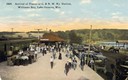
| Date: | |
|---|---|
| Description: | Elevated view of passengers arriving on the Chicago & Northwestern Railroad train at the Williams Bay station. Many automobiles are parked near the depot, ... |
| Date: | 1936 |
|---|---|
| Description: | Crescent Beach campsite with cabins and miniature golf course by Lake Michigan. |

| Date: | 1941 |
|---|---|
| Description: | Official highway map of Wisconsin, "the playground of the Midwest," showing the state transportation network prior to World War II. |

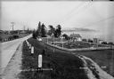
| Date: | 1934 |
|---|---|
| Description: | Tourist camp at Lakeside Park on Lake Winnebago. |
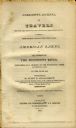
| Date: | 1820 |
|---|---|
| Description: | Narrative Journal of Travels through the northwestern regions of the United States, extending from Detroit through the great chain of American lakes to the... |
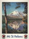
| Date: | 1947 |
|---|---|
| Description: | An original lithograph promoting Mt. St. Helens, and to get there by way of the Northern Pacific Railway. Featuring the artwork of Gustav Krollmann, it dep... |

| Date: | 1936 |
|---|---|
| Description: | An original lithograph promoting New Hampshire as the "Land of Scenic Splendor." The poster features the artist Maxwell Parrish's depiction of a New Hampsh... |

| Date: | 1884 |
|---|---|
| Description: | Cover art for a pamphlet advertising The Apostle Islands and Lake Superior. The upper half of the artwork depicts a sunset view of Lake Superior, and the b... |
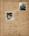
| Date: | 06 26 1940 |
|---|---|
| Description: | Page from the Neighborhood House log book of bike hosteling trips sponsored by the settlement house, with images of girls on their bikes and resting on a d... |
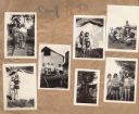
| Date: | 1930 |
|---|---|
| Description: | Page from the Tansy Camp Fire Girls album kept by Neighborhood House, with groups of girls posing at the end of a pier, in front of tents, on the remains o... |

| Date: | 1946 |
|---|---|
| Description: | Reproduction of a painting depicting an Olympian Hiawatha locomotive and an Olympian Hiawatha observation car traveling in the western United States. A man... |

| Date: | 1953 |
|---|---|
| Description: | This map shows locations of State Medical Society, nine medical facilities, two University of Wisconsin buildings, four transportation centers, and five ho... |

| Date: | 1975 |
|---|---|
| Description: | This map shows transportation routes taken by public transit. Includes a key to bus routes, schedule, and transit information. Includes labels for streets,... |

| Date: | 1935 |
|---|---|
| Description: | This map is presented by Conoco, and shows the major roads, cities, lakes, and rivers, as well as some of the neighboring states. It includes an index, sca... |

| Date: | 1946 |
|---|---|
| Description: | This colored road map shows automobile roads in Wisconsin as well as portions of nearby states. Information on the quality and type of any road shown (Inte... |

| Date: | 1948 |
|---|---|
| Description: | This colored road map shows automobile roads in Wisconsin as well as portions of nearby states.Information on the quality and type of any road shown (bitum... |

| Date: | 1948 |
|---|---|
| Description: | This colored road map shows automobile roads in Wisconsin as well as portions of nearby states. The map is organized such that a single map of Wisconsin is... |

| Date: | 1956 |
|---|---|
| Description: | This colored road map shows automobile roads in Wisconsin as well as portions of nearby states. The map is organized such that a single map of Wisconsin is... |

| Date: | 1959 |
|---|---|
| Description: | This colored road map shows roads in Wisconsin as well as portions of nearby states. Information on the quality and type of any road shown (expressways, St... |
If you didn't find the material you searched for, our Library Reference Staff can help.
Call our reference desk at 608-264-6535 or email us at: