 Filter: Categories of Wisconsin Historical Images
Filter: Subject of Transportation, Military
Filter: Subject of fortification
Filter: Categories of Wisconsin Historical Images
Filter: Subject of Transportation, Military
Filter: Subject of fortification
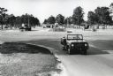
| Date: | 1964 |
|---|---|
| Description: | A man drives an International Harvester Scout past military vehicles on display near the entrance to Fort Stewart. |

| Date: | 02 1777 |
|---|---|
| Description: | Map depicting the campaigns of October and November 1776, in Manhattan, Westchester, and part of New Jersey, published only a few months after the conclusi... |

| Date: | 11 1781 |
|---|---|
| Description: | Map of New York, Staten Island, and Long Island, showing the placements of forts, and the movement of troops in 1776. The map also includes towns, cities, ... |

| Date: | 04 1777 |
|---|---|
| Description: | Map showing the area from Newtown, Pennsylvania to Kingston, New Jersey, with routes and battles of British (red) and American forces (blue). The map inclu... |

| Date: | |
|---|---|
| Description: | Transporting food containers at an elevation of 3500 meters. |
If you didn't find the material you searched for, our Library Reference Staff can help.
Call our reference desk at 608-264-6535 or email us at:
