Filter: Categories of Wisconsin Historical Images
Filter: Subject of Transportation
Filter: County of Grant
Filter: Categories of Wisconsin Historical Images
Filter: Subject of Transportation
Filter: County of Grant
| Date: | 08 1925 |
|---|---|
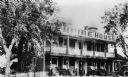
| Description: | A view of the front of the Empire House Hotel, showing the porch and balcony. There are many wicker chairs on the porch, and there is an automobile parked ... |
| Date: | 1950 |
|---|---|
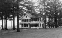
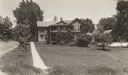
| Description: | View across lawn towards the Gray-Williams house. |
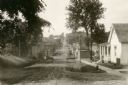
| Date: | 1920 |
|---|---|
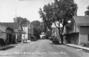
| Description: | View down center of Main Street, with a gas filling station and garage on the left side of the road. Caption reads: "Main Street, Hazel Green, Wis." |
| Date: | 1920 |
|---|---|
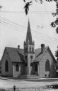
| Description: | View across street towards a Methodist church. Caption reads: "Methodist Church, Hazel Green, Wis." |
| Date: | |
|---|---|
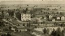
| Description: | An engraving based on a drawing by Alexander Simplot of the Platteville Brewery (spelled Plattville). It is an elevated perspective showing the main buildi... |
| Date: | 1930 |
|---|---|
| Description: | The home of Joel Allen Barber, who helped frame the present constitution of Wisconsin. |

| Date: | 1950 |
|---|---|
| Description: | View across intersection of City Hall on a street corner. |

| Date: | 1915 |
|---|---|
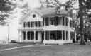
| Description: | View across road towards Governor Nelson Dewey's house. |

| Date: | 1925 |
|---|---|
| Description: | View across road towards Governor Nelson Dewey's house. |
| Date: | 1865 |
|---|---|
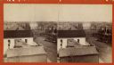
| Description: | Stereograph of an elevated view of Court House Square in Lancaster. |
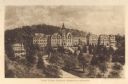
| Date: | 1910 |
|---|---|
| Description: | Elevated view of Saint Clara Academy, formerly known as Saint Clara College. Caption reads: "Saint Clara College — Sinsinawa, Wisconsin". |
| Date: | 1928 |
|---|---|
| Description: | View down dirt road. Houses are on the right. Further down the road are commercial buildings and automobiles. |
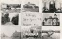
| Date: | 1909 |
|---|---|
| Description: | Composite of views of Muscoda including: Electric Light plant, Smalley House, St. John Catholic Church, Lover's Lane, Muscoda Public School, Wisconsin Aven... |

| Date: | |
|---|---|
| Description: | Plan of township no. 3 north, range no. 5 west of the 4th principal meridian. |
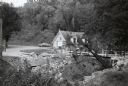
| Date: | 1958 |
|---|---|
| Description: | Nelson Dewey State Park (Cassville vicinity). Bridge construction near the park office which was built in the 1850s as a chicken house. The park was establ... |
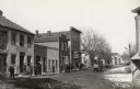
| Date: | 1906 |
|---|---|
| Description: | View down unpaved street with snow along the curbs. The Post office is the first building on the left. Other buildings are occupied by a doctor's office, s... |
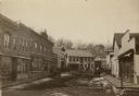
| Date: | 1906 |
|---|---|
| Description: | View down unpaved street of lined with commercial buildings. Pedestrians are on the sidewalks, and some snow is along the curbs. In the background is a hil... |
If you didn't find the material you searched for, our Library Reference Staff can help.
Call our reference desk at 608-264-6535 or email us at: