 Filter: Categories of Wisconsin Historical Images
Filter: Subject of Transportation
Filter: Community of Blooming Grove
Filter: Categories of Wisconsin Historical Images
Filter: Subject of Transportation
Filter: Community of Blooming Grove
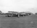
| Date: | 05 26 1932 |
|---|---|
| Description: | At Royal Airport, a line of airplanes are parked in a row in a field. In the background is a hangar with automobiles parked nearby. |

| Date: | 1911 |
|---|---|
| Description: | Plat Map of Blooming Grove in "Atlas of Dane County, Wisconsin." |
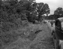
| Date: | 08 17 1946 |
|---|---|
| Description: | Skid-path of the Greyhound bus that crashed on Highway 12 about 2 miles east of Madison. The bus left the highway, plunged 200 feet along a ditch, hit a d... |
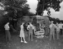
| Date: | 08 17 1946 |
|---|---|
| Description: | Several bystanders are observing the damage to a Greyhound bus turned over on its side as the result of an accident on Highway 12 about 2 miles east of Mad... |

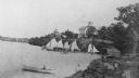
| Date: | 1895 |
|---|---|
| Description: | view from the hotel of the expansive grounds of the Tonyawatha Spring Hotel on Lake Monona. Located in Blooming Grove Township, the hotel was opened in 187... |
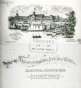
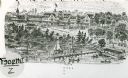
| Date: | 1885 |
|---|---|
| Description: | From the cover of a descriptive brochure in the Historical Society's Library pamphlet collection, this drawing depicts the large hotel grounds on Lake Mono... |

| Date: | 1889 |
|---|---|
| Description: | From a map published by Angell and Hastreither, the drawing depicts the Tonyawatha Spring Hotel grounds on Lake Monona. The hotel, located in Blooming Grov... |
| Date: | 1895 |
|---|---|
| Description: | View of the Tonyawatha Spring Hotel grounds, located on Lake Monona in Blooming Grove Township, just outside of Madison. The hotel opened in 1879 and on Ju... |
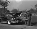
| Date: | 10 13 1948 |
|---|---|
| Description: | Blooming Grove constables Albert Frazer and Jerry Fries, put a man on a stretcher in the back of a police car modified to serve as ambulance. |

| Date: | 07 28 1950 |
|---|---|
| Description: | Four children with three decorated bicycles and a doll buggy at Gallagher Plat playground. |
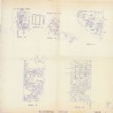
| Date: | 1993 |
|---|---|
| Description: | This collection of maps includes two pages of seven detailed plats of different sub divisions and areas of the township. |
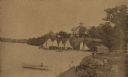
| Date: | 08 30 1884 |
|---|---|
| Description: | View along shoreline towards Tonyawatha House. A man or woman is in a rowboat in the foreground, and a large group of people are on a pier near five or six... |

| Date: | |
|---|---|
| Description: | Farm workers spreading hay onto two haystacks on farm on the east side of Highway 51 north of Pflaum Road. Three teams of horses, wearing fly-nets, are pro... |

| Date: | |
|---|---|
| Description: | Aerial view looking west along Pflaum Road taken from the east of Stoughton Road, Monona, and Lake Monona in the distance. The Wisconsin State Capitol and ... |

| Date: | |
|---|---|
| Description: | Aerial view looking north along Stoughton Road from south of Pflaum Road. |
| Date: | 08 30 1884 |
|---|---|
| Description: | View along the Lake Monona shoreline towards the Tonyawatha Spring Hotel. A crowd of people are standing on the pier with several sailboats. On the shore i... |
If you didn't find the material you searched for, our Library Reference Staff can help.
Call our reference desk at 608-264-6535 or email us at: