 Filter: Categories of Wisconsin Historical Images
Filter: Subject of Transportation
Filter: Creator Name of Brown, Charles E.
Filter: Subject of land use
Filter: Categories of Wisconsin Historical Images
Filter: Subject of Transportation
Filter: Creator Name of Brown, Charles E.
Filter: Subject of land use
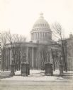
| Date: | 1899 |
|---|---|
| Description: | View from street through gates towards the Third Wisconsin State Capitol, the second in Madison, as seen from East Washington Avenue. The iron fence and st... |
| Date: | |
|---|---|
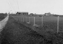
| Description: | Distant view of Waterbury mansion, with field, road and fencing in the foreground. |

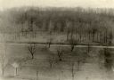
| Date: | 1915 |
|---|---|
| Description: | A row of conical burial mounds adjoins the Park and Pleasure Drive on the north shore of Lake Wingra (now Edgewood Drive, at the south edge of Edgewood Col... |
| Date: | |
|---|---|
| Description: | Elevated view of Man Mound outlined in chalk looking south. A road bisects the legs of the effigy mound. A small outbuilding can be seen at left in the for... |

| Date: | 1944 |
|---|---|
| Description: | Portage County Map. Includes the towns of Eau Plaine, Dewey, Sharon, Alban, Carson, Hull, New Hope, Linwood, Stockton, Amherst, Plover, Grant, Buena Vista,... |

| Date: | 11 03 1903 |
|---|---|
| Description: | A drawing of a group of burial mounds in Linden Valley. Text on back reads: "These mounds lie at the narrow mouth of Linden Valley on the east side of the ... |

| Date: | 1924 |
|---|---|
| Description: | A map of the Madison Township, T7N R9E including Lake Mendota showing the location of Ho Chunk encampments and effigy mounds. |
If you didn't find the material you searched for, our Library Reference Staff can help.
Call our reference desk at 608-264-6535 or email us at: